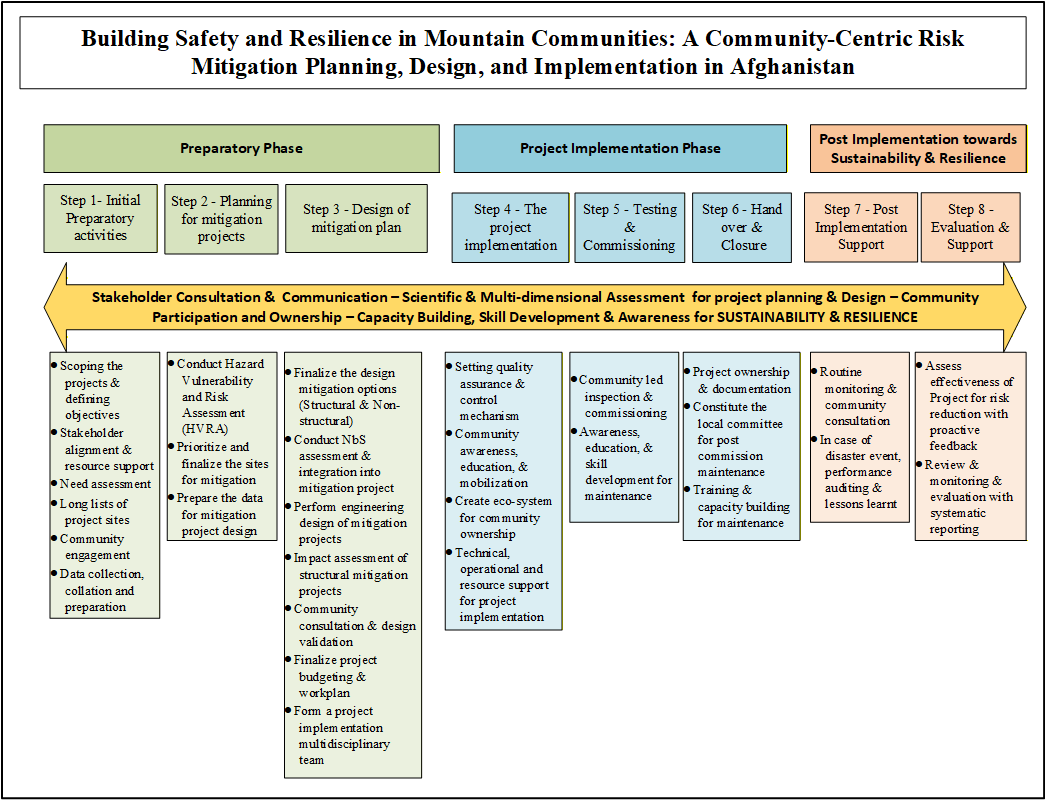
Afghanistan’s mountain communities are increasingly exposed to floods, landslides, avalanches and rockfalls as a result of climate change, environmental degradation and socio-economic fragility, while practical and sustainable models for community-centred risk mitigation remain limited. In this study, a comprehensive practice-led framework for building safety and resilience in mountainous Afghanistan is presented based on 22 mitigation projects implemented across five high-risk provinces by the Aga Khan Agency for Habitat (AKAH). The national hazard scape is first characterised using EM-DAT disaster trends, which indicate the dominance of hydro-meteorological hazards in driving human and economic losses. The physical, ecological and socio-institutional constraints shaping mountain hazard mitigation strategies are subsequently outlined, with emphasis placed on terrain instability, climatic extremes, resource limitations and governance challenges. A structured eight-step community-centric methodology anchored in participatory Hazard, Vulnerability and Risk Assessment (HVRA), risk-informed planning, and blended structural and Nature-based Solutions (NbS) is then described. Scientific tools such as GIS-based hazard mapping and numerical modelling are integrated with indigenous knowledge to support site prioritisation, design optimisation, and locally owned implementation, operation and maintenance. Observation and results indicate that approximately 12.5 km2 of land, including 2.95 km2 of agricultural land, more than 550 households, over 4900 people and 58 critical infrastructure units are safeguarded through these interventions. Scenario-based hazard modelling demonstrates that rockfall impact area is reduced by 47% and population at risk by 92% in Bezokh village, while flood inundation extent is reduced by 55% in Baghlan following construction of a protective river wall. NbS feasibility assessments conducted at 12 sites achieve scores of up to 74% against the IUCN Global Standard, indicating strong ecological suitability, technical performance and community relevance. Recurring implementation challenges are identified, including weak regulatory frameworks, limited availability of risk data, capacity constraints and logistical barriers in remote mountain settings. However, a consistent causal relationship is observed in which evidence-based HVRA, co-designed hybrid mitigation measures, community-led quality assurance and sustained operation and maintenance collectively lead to measurable reductions in hazard exposure and strengthened resilience. It is concluded that this integrated, community-centric and risk-informed model provides a scalable and transferable pathway for climate-resilient infrastructure development and disaster risk reduction in fragile mountain environments within Afghanistan and comparable regions worldwide.
- Open Access
- Article
Building Safety and Resilience in Mountain Communities: A Community-Centric Risk Mitigation Planning, Design, and Implementation in Afghanistan
- Amit Kumar 1,*,
- Noorudin Akbari 2,
- Deo Raj Gurung 3,
- Mohammad Elyas Hamidi 2,
- Khwaja Momin Walizada 2,
- Rahim Dobariya 2,
- Dawlatbaig Kawish 2
Author Information
Received: 21 Sep 2025 | Revised: 17 Nov 2025 | Accepted: 30 Dec 2025 | Published: 14 Jan 2026
Abstract
Graphical Abstract
Keywords
hazard vulnerability and risk assessment (HVRA) | community-based planning & design | nature-based solutions (NbS) | structural and non-structural measures | project impact assessment
References
- 1.
Accomack County. (n.d.). Hazard Mitigation Plan. Accomack County, Virginia. Available online: https://www.co.accomack.va.us/departments/emergency-management/county-government/hazard-mitigation-plan#:~:text=Hazard%20Mitigation%20is%20defined%20as,facility%20from%20a%20disaster%20event (accessed on 5 December 2025).
- 2.
Josè Moisès, D.; Kgabi, N.; Kunguma, O. Integrating “top-down” and “community-centric” approaches for community-based flood early warning systems in Namibia. Challenges 2023, 14, 44.
- 3.
Pham, T.D.M.; Thieken, A.H.; Bubeck, P. Community-based early warning systems in a changing climate: An empirical evaluation from coastal central Vietnam. Clim. Dev. 2024, 16, 673–684.
- 4.
Wati, R.; Sujianto, S.; Heriyanto, M.; et al. Community-Based Social Capital as a Pillar of Disaster Mitigation in Coastal Areas. In Proceedings of the E3S Web of Conferences, EDP Sciences, Virtual, 10 December 2025; Volume 611, p. 05001.
- 5.
Maskrey, A. Defining the Community’s Role in Disaster Mitigation. 1992. Technical Brief, Practical Action. Available online: https://infohub.practicalaction.org/server/api/core/bitstreams/599bc6b5-f568-43d0-8c73-b3b845350f58/content (accessed on 6 December 2025)
- 6.
Corbin, T.B. Community based mitigation strategies: Building resilience in rural Appalachia. In Case Studies in Disaster Mitigation and Prevention; Butterworth-Heinemann: Oxford, UK, 2023; pp. 19–44.
- 7.
Lorna, P.V. Community-based approaches to disaster mitigation. In Proceedings of the Regional Workshop on Best Practices in Disaster Mitigation: Lessons learned from the Asian Urban Disaster Mitigation Program and Other Initiatives, Bali, Indonesia, 24–26 September 2002; pp. 24–26. Available online: https://alnap.org/help-library/resources/community-based-approaches-to-disaster-mitigation/ (accessed on 5 December 2025).
- 8.
Rajmil, D.; Morales, L.; Aira, T.; et al. Afghanistan: A multidimensional crisis. Peace Rev. 2022, 34, 41–50. https://doi.org/10.1080/10402659.2022.2023700.
- 9.
Aga Khan Development Network (AKDN). (2025). Improving the Quality of Life. Available online: https://www.akdn.org/en/home (accessed on 1 December 2025).
- 10.
Dobariya, R.; Bano, D.; Momin, K.; et al. Community level risk assessment using GIS—An innovative method for participatory risk assessment. In Proceedings of the 2nd International Symposium on Disaster Resilience and Sustainable Development, Pathum Thani, Thailand, 24–25 June 2021; Pal, I., Kolathayar, S., Islam, S.T., et al., Eds.; Springer: Berlin, Germany, 2023; Volume 294, pp. 207–221. https://doi.org/10.1007/978-981-19-6297-4_19.
- 11.
IUCN. Global Standard for Nature-Based Solutions: A User-Friendly Framework for the Verification; IUCN: Grand, Switzerland, 2020. https://doi.org/10.2305/IUCN.CH.2020.08.en.
- 12.
Calista, M.; Menna, V.; Mancinelli, V.; et al. Rockfall and debris flow hazard assessment in the SW escarpment of Montagna del Morrone Ridge (Abruzzo, Central Italy). Water 2020, 12, 1206. https://doi.org/10.3390/w12041206.
- 13.
Wachino, I.D.; Roering, J.J.; Cash, R.; et al. Characterizing rockfall hazard with an integrated kinematic analysis and runout model: Skagway, Alaska, USA. EGUsphere 2025, 2025, 1–33. https://doi.org/10.5194/egusphere-2025-1168.
- 14.
Kakavas, M.P.; Nikolakopoulos, K.G. Digital elevation models of rockfalls and landslides: A review and meta-analysis. Geosciences 2021, 11, 256.
- 15.
Žabota, B.; Kobal, M. A new methodology for mapping past rockfall events: From mobile crowdsourcing to rockfall simulation validation. ISPRS Int. J. Geo-Inf. 2020, 9, 514.
- 16.
Devi, D.; Dhital, S.; Munasinghe, D.; et al. A Framework for the Evaluation of Flood Inundation Predictions over Extensive Benchmark Databases. Environ. Model. Softw. 2025, 106786.

This work is licensed under a Creative Commons Attribution 4.0 International License.
 Suite 4002 Level 4, 447 Collins Street, Melbourne, Victoria 3000, Australia
 General Inquiries: info@sciltp.com