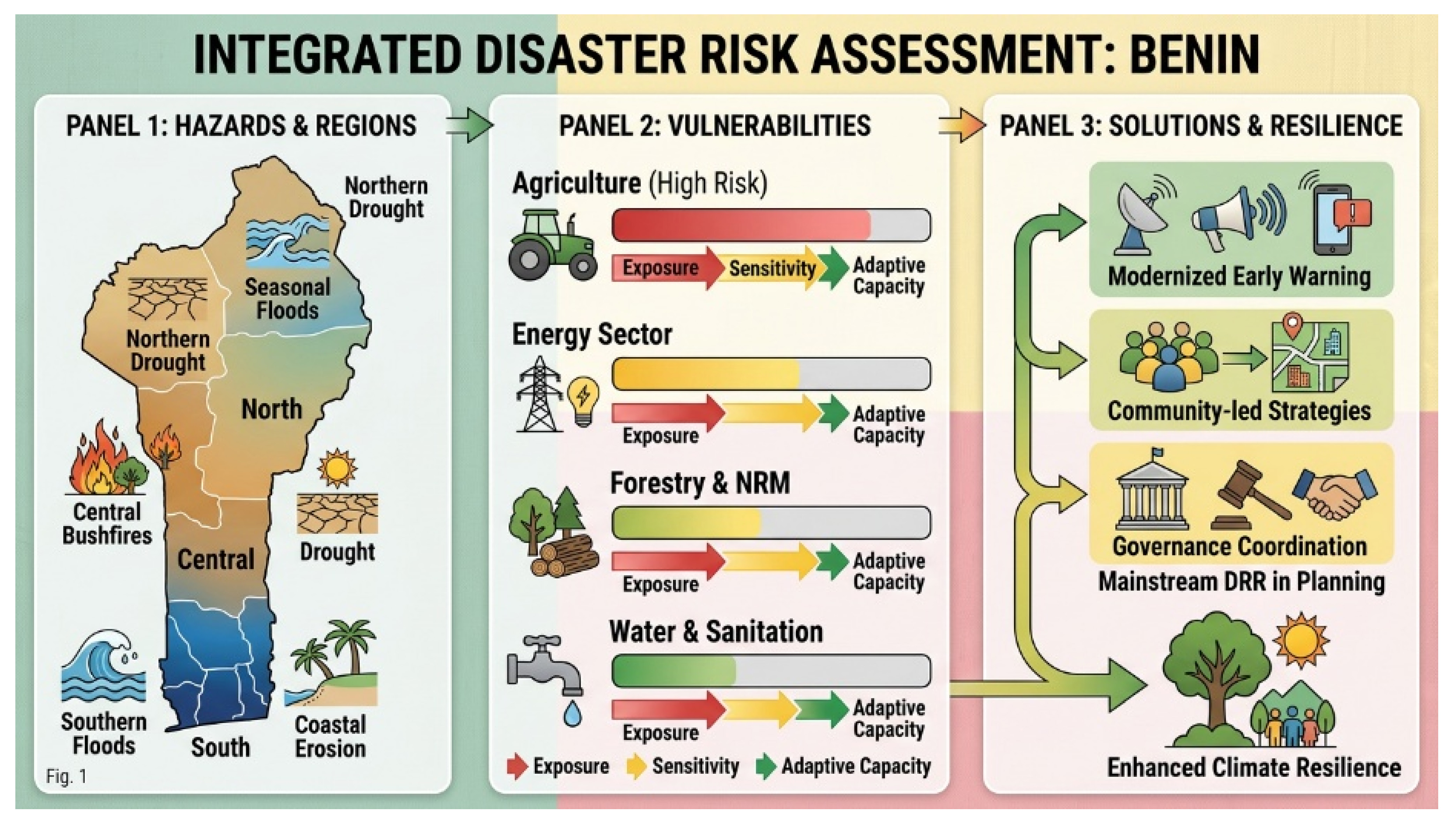
Benin is increasingly exposed to climate-related and geophysical hazards whose frequency and intensity are amplified by climate change, rapid urbanisation, environmental degradation, and limited institutional capacity. This study presents an integrated assessment of the disaster risk landscape in Benin, with a particular focus on sectoral vulnerabilities and the role of urban and territorial planning in disaster risk reduction. A mixed-methods approach was employed, combining qualitative policy analysis and quantitative spatial and statistical techniques. Data were collected from national strategic frameworks, including Benin’s National Disaster Risk Reduction Strategy, National Adaptation Plan, National Action Plan for Sustainable Land Management (PAN-GDT 2018–2027), nationally determined contribution documents, spatial planning schemes, and post-disaster needs assessments. Spatial analysis of land use, infrastructure, and hazard exposure was integrated with statistical analysis of historical disaster data, climate trends, and socioeconomic indicators. Vulnerability, adaptive capacity, and institutional readiness were evaluated using the World Bank Climate and Disaster Risk Screening Tools based on an exposure-sensitivity-adaptive capacity framework. Results reveal a highly heterogeneous risk profile across the country. Southern coastal zones are predominantly exposed to flooding and coastal erosion; central plateau areas face recurrent bushfires and drought; while northern regions are characterised by severe drought and seasonal flooding along major river systems. Agriculture, energy, natural resource management/forestry, and water and sanitation emerge as the most vulnerable sectors, facing high levels of both current and future risk. Institutional assessments indicate disparities in preparedness, with relatively stronger capacities in agriculture and natural resource management, but gaps in awareness, adaptation implementation, and early warning infrastructure in other sectors. The study highlights the critical need to mainstream disaster risk reduction into urban and territorial planning, strengthen governance coordination, modernise meteorological and hydrological observation systems, and enhance community-centred resilience strategies. Integrating risk considerations into land use planning and sectoral policies is essential to reduce vulnerability and support sustainable development in Benin under increasing climate pressure. In addition, this work advances disaster risk research in Benin by integrating multiple dimensions hazard exposure, sectoral vulnerability, institutional capacity, and policy frameworks into a cohesive analysis. It offers actionable insights for policymakers, providing an evidence-based foundation to support integrated disaster risk reduction and climate adaptation strategies at both national and local levels.
- Open Access
- Article
Applying Integrated Climate and Disaster Risk Assessment to Land Use Planning and Development Policy in Benin
- Gouvidé Jean Gbaguidi 1,*,
- Nadège I. P. Dossoumou 1,
- Nikita Topanou 2 and
- Walter Leal Filho 3,4
Author Information
Received: 05 February 2026 | Revised: 01 April 2026 | Accepted: 22 April 2026 | Published: 09 May 2026
Abstract
Graphical Abstract
Keywords
climate change | disaster risk reduction | vulnerability assessment | climate resilience | Benin
References
- 1.
Joshi, N.; Wende, W.; Tiwari, P.C. Urban Planning as an Instrument for Disaster Risk Reduction in the Uttarakhand Himalayas. Mt. Res. Dev. 2022, 42, D13–D21. https://doi.org/10.1659/MRD-JOURNAL-D-21-00048.1.
- 2.
ISDR. Statement by the Delegation of ISDR to the Sixteenth Session of the United Nations Commission on Sustainable Development Thematic Discussion: Drought. 2008. Available online: https://digitallibrary.un.org/record/603095/files/isdr-biblio-2-drought-2007.pdf (accessed on 12 March 2024).
- 3.
National Determined Contribution. Updated Nationally Determined Contribution of Benin under the Paris Agreement (Final document), General Directorate of Environment and Climate. 2021. Available online: https://unfccc.int/sites/default/files/NDC/2022-06/CDN_ACTUALISEE_BENIN2021.pdf (accessed on 13 February 2024).
- 4.
Post-Disaster Needs Assessment Report. Floods in Benin—Post-Disaster Needs Assessment Report. 2011. Available online: https://documents1.worldbank.org/curated/en/750141468208769683/pdf/694130ESW0P1240lood0Recovery0Report.pdf (accessed on 12 March 2024).
- 5.
National Adaptation Plan. National Adaptation Plan to Climate Change of Benin, Ministry of Living Environment and Sustainable Development, General Directorate of Environment and Climate (DGEC). May 2022. Available online: https://unfccc.int/sites/default/files/resource/PNA_BENIN_2022_0.pdf (accessed on 30 December 2023).
- 6.
National Determined Contribution. Updated Nationally Determined Contribution of Benin under the Paris Agreement (Final document), General Directorate of Environment and Climate. 2009. Available online: https://unfccc.int/sites/default/files/NDC/2022-06/CDN_ACTUALISEE_BENIN2021.pdf (accessed on 14 March 2024).
- 7.
Chokpon, A.E.; Ozer, P.; Lawin, E. Assessment of Flood Risk in Cotonou Areas Surrounding Nokoué Lake Due to the Effect of Climate Change. J. Geosci. Environ. Prot. 2021, 9, 262–279. https://doi.org/10.4236/gep.2021.93016.
- 8.
The World Bank. Strengthening Disaster Risk Management in Urban Planning and Municipal Development. 2022. Available online: https://www.worldbank.org/ (accessed on 23 May 2024).
- 9.
Oluwagbemiga Paul, A.; Uduma-Olugu, N. Exploring the symbiotic relationship between smart technologies and thermal comfort in urban environments. Soc. Sci. Humanit. Open 2024, 10, 100943. https://doi.org/10.1016/j.ssaho.2024.100943.
- 10.
Effiong, C.; Ngang, E.; Ekott, I. Land use planning and climate change adaptation in river-dependent communities in Nigeria. Environ. Dev. 2024, 49, 100970. https://doi.org/10.1016/j.envdev.2024.100970.
- 11.
The World Bank. World Bank Group. Climate Change Knowledge Portal (CCKP): Benin. 2026. Available online: https://climateknowledgeportal.worldbank.org/country/benin (accessed on 28 April 2025).
- 12.
Government of Benin. Benin—National Disaster Risk Reduction Strategy; Government of Benin: Cotonou, Benin, 2019.
- 13.
Centre for Research on the Epidemiology of Disasters (CRED). EM-DAT: The International Disaster Database. Available online: https://www.emdat.be/ (accessed on 28 April 2025).
- 14.
The World Bank. Climate and Disaster Risk Screening Tools. Available online: https://climatescreeningtools.worldbank.org/ (accessed on 20 October 2024).
- 15.
Zheng, Z.; Fong, C.S.; Aghamohammadi, N.; et al. A Systematic Review of Urban Heat Island (UHI) Impacts and Mitigation: Health, Equity, and Policy. Systems 2026, 14, 82. https://doi.org/10.3390/systems14010082.
- 16.
Yang, X.; Xu, X.; Wang, Y.; et al. Heat exposure impacts on urban health: A meta-analysis. Sci. Total Environ. 2024, 949, 174650. https://doi.org/10.1016/j.scitotenv.2024.174650.
- 17.
World Health Organization. Heat and Health. 2024. Available online: https://www.who.int/news-room/fact-sheets/detail/climate-change-heat-and-health (accessed on 22 October 2024).
- 18.
World Health Organization. Climate Change. 2024. Available online: https://www.who.int/news-room/fact-sheets/detail/climate-change-and-health (accessed on 21 October 2024).
- 19.
International Labour Organization. Working on a Warmer Planet: The Impact of Heat Stress on Labour Productivity and Decent Work. International Labour Office. 2019. Available online: https://www.ilo.org/global/publications/books/WCMS_711919/lang--en/index.htm (accessed on 23 December 2023).
- 20.
National Contingency Plan. National Contingency Plan 2024. 2024. Available online: https://fscluster.org/sites/default/files/2024-07/Plan%20de%20contingence%20et%20r%C3%A9ponses%20aux%20inondations%202024.pdf (accessed on 23 December 2023).
- 21.
Government of Benin & United Nations Development Programme. Benin: Post-Disaster Needs Assessment (PDNA)—Floods 2022. 2022. Available online: https://reliefweb.int/report/benin/benin-floods-2022-dref-final-report-mdrbj017 (accessed on 23 December 2023).
- 22.
PAN-GDT 2018–2027. National Action Plan for Sustainable Land Management (PAN-GDT) 2018–2027. 2019. Available online: https://faolex.fao.org/docs/pdf/ben197393.pdf (accessed on 23 December 2023).
- 23.
National Adaptation Plan to Climate Change of Benin. National Adaptation Plan to Climate Change of Benin, Ministry of Living Environment and Sustainable Development, General Directorate of Environment and Climate (DGEC). 2022. Available online: https://unfccc.int/sites/default/files/resource/PNA_BENIN_2022_0.pdf (accessed on 23 December 2023).
- 24.
Spatial Planning Agenda of Benin. Spatial Planning Agenda of Benin: Towards Balanced National Territorial Development through Three Complementary Options. 2017. Available online: https://sgg.gouv.bj/upload/files/documentheque/0487709001553274214.pdf (accessed on 29 April 2025).
- 25.
United Nations Development Programme (UNDP). Benin: A Country Vulnerable to Climate Change. 2020. Available online: https://www.undp.org/fr/benin/publications/le-benin-un-pays-vulnerable-aux-changements-climatiques (accessed on 29 April 2025).

This work is licensed under a Creative Commons Attribution 4.0 International License.