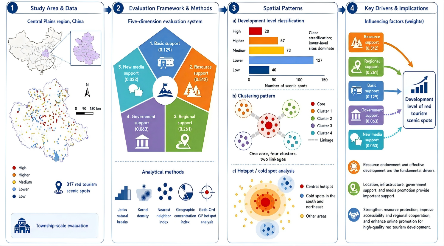
Red tourism is a distinctive form of cultural tourism in China, centered on revolutionary heritage and national memory. However, existing studies have often focused on individual sites or administrative units, lacking systematic evaluations at a broader regional scale and overlooking the combined effects of multiple influencing factors. To address these gaps, this study takes the Central Plains region as a case study and evaluates the development level of 317 red tourism scenic areas. A five-dimensional evaluation framework was constructed, incorporating basic support, resource support, regional support, government support, and new media support. Spatial classification, spatial clustering, and spatial association methods were employed to analyze spatial differentiation patterns and development characteristics. The results show that development levels vary significantly across sites, forming a stratified distribution pattern. High-level scenic areas are relatively evenly distributed, while medium- and higher-level scenic areas cluster in the central and northern parts of the region, and lower-level sites are concentrated in Zhengzhou, Xinyang, Liaocheng, and Changzhi. The overall distribution follows a core–cluster structure, with high-value hotspots in Kaifeng and cold spots in Xinxian and northeastern Luoyang. Further analysis indicates that resource endowment and effective development are the fundamental drivers of red tourism growth, while location, infrastructure, government support, and media promotion play important supporting roles. This study expands the evaluation perspective of red tourism by adopting a township-scale analysis and provides new insights for regional tourism planning, heritage protection, and the sustainable development of red tourism resources.
- Open Access
- Article
Evaluating and Identifying Influencing Factors of the Development Level of Regional Red Tourism Scenic Spots: A Case Study of the Central Plains Region
- Jiayuan Mao 1,
- Zechen Wang 2,
- Zhiwei Ding 3,*
Author Information
Received: 05 Jan 2026 | Revised: 12 Feb 2026 | Accepted: 09 Mar 2026 | Published: 23 Mar 2026
Abstract
Graphical Abstract
Keywords
red tourism | development evaluation | spatial analysis | influencing factors | Central Plains region
References
- 1.
Li, S. The politicization of place: Chronotopes, authenticity, and semioscaping Fujialu as a site of “red tourism” in China. Soc. Semiot. 2024, 34, 870–891. https://doi.org/10.1080/10350330.2023.2216636.
- 2.
Kou, Y.; Xue, X. The influence of rural tourism landscape perception on tourists’ revisit intentions—A case study in Nangou village, China. Humanit. Soc. Sci. Commun. 2024, 11, 1–14. https://doi.org/10.1057/s41599-024-03129-8.
- 3.
Zhou, X.; Wong, J.W.C.; Wang, S. Memorable Tourism Experiences in Red Tourism: The case of Jiangxi, China. Front. Psychol. 2022, 13, 899144. https://doi.org/10.3389/fpsyg.2022.899144.
- 4.
Wang, F.; Sanagustín-Fons, V.; Martínez-Quintana, V. Red Tourism and Youth Education: A Systematic Review of the Literature. Societies 2025, 15, 69. https://doi.org/10.3390/soc15030069.
- 5.
Li, H.; Hiromu, I. Comparative analysis of information tendency and application features for projection mapping technologies at cultural heritage sites. Herit. Sci. 2021, 9, 1. https://doi.org/10.1186/s40494-021-00579-0.
- 6.
Akbulut, O. The Meaning and Definition of Battlefield Tourism: What Is Battlefield Tourism? Emerald Publishing Limited: Bingley, UK, 2024; pp. 35–74. https://doi.org/10.1108/978-1-83909-990-820241005.
- 7.
Işıldar, P. Historical Background of Battlefield Tourism; Emerald Publishing Limited: Bingley, UK, 2024; pp. 75–97. https://doi.org/10.1108/978-1-83909-990-820241006.
- 8.
Carbone, F. War-related attractions: The good, the bad, or the ugly? War museums between peace, national identity and war porn. Curr. Issues Tour. 2024, 27, 679–688. https://doi.org/10.1080/13683500.2023.2256943.
- 9.
Liu, Y.; Qiao, J.; Xiao, J.; et al. Evaluation of the Effectiveness of Rural Revitalization and an Improvement Path: A Typical Old Revolutionary Cultural Area as an Example. Int. J. Environ. Res. Public. Health 2022, 19, 13494. https://doi.org/10.3390/ijerph192013494.
- 10.
Zhu, Y.Y.; Wang, Z.W.; Gu, J.; et al. The spatial optimization of red tourism resources utilization based on the resilience of ruralism–ecology system: A case study of Dabie Mountains Old Revolutionary Base Area. J. Nat. Resour. 2021, 36, 1700–1717. https://doi.org/10.31497/zrzyxb.20210706.
- 11.
Calderon-Fajardo, V. Future trends in Red Tourism and communist heritage tourism. Asia Pac. J. Tour. Res. 2023, 28, 1185–1198. https://doi.org/10.1080/10941665.2023.2289415.
- 12.
Yang, L.; Chen, J.-J.; Shi, P.-F.; et al. The evaluation of red tourism development efficiency and its influencing factors: A case study of the red tourism region in Northern and Western Guizhou. J. Nat. Resour. 2021, 36, 2763–2777. https://doi.org/10.31497/zrzyxb.20211104.
- 13.
Zuo, B.; Gursoy, D.; Wall, G. Residents’ support for red tourism in China: The moderating effect of central government. Ann. Tour. Res. 2017, 64, 51–63. https://doi.org/10.1016/j.annals.2017.03.001.
- 14.
Liao, Z.; Wang, L. Spatial differentiation and influencing factors of red tourism resources transformation efficiency in China based on RMP-IO analysis. Sci. Rep. 2024, 14, 10761. https://doi.org/10.1038/s41598-024-61021-6.
- 15.
Nong, F.; Gu, J.; He, R.; et al. Measurement and Dynamic Evolution Analysis of Coupling Coordination of Red Tourism and Rural Revitalization. In Proceedings of the 3rd International Conference Economic Management and Big Data Application, Dalian, China, 25–27 October 2024; pp. 323–337. https://doi.org/10.1142/9789811270277_0029.
- 16.
Yan, S.; Shi, Z.; Zhu, W.; et al. Developing Ecological Security Pattern Based on Clustering Algorithm and Interpretable Machine Learning: A Case Study of Zhengzhou Metropolitan Area, China. Land Degrad. Dev. 2026, 1–25. https://doi.org/10.1002/ldr.70549.
- 17.
Zhou, H.; Ma, Y.; Fan, Y.; et al. Spatial distribution and accessibility analysis of red tourism resources in Inner Mongolia. Arid. Land. Geogr. 2023, 46, 814–822. http://alg.xjegi.com/EN/10.12118/j.issn.1000-6060.2022.423.
- 18.
Zhou, H.; Zhang, Q.; Lu, L.; et al. Research on the influence path of red tourism experience on tourists’ well-being: Based on the chain mediating role of tourists’ emotion and national identity. BMC Psychol. 2025, 13, 12. https://doi.org/10.1186/s40359-025-02435-3.
- 19.
Yun, M.-N. Translation strategies of red tourism terms in the Central Plains—Taking Red Central Plains as an example. J. Lit. Art. Stud. 2024, 14, 133–137. https://doi.org/10.17265/2159-5836/2024.02.005.
- 20.
Song, Q.; Wang, Z.; Wu, T. Risk analysis and assessment of water resource carrying capacity based on weighted gray model with improved entropy weighting method in the central plains region of China. Ecol. Indic. 2024, 160, 111907. https://doi.org/10.1016/j.ecolind.2024.111907.
- 21.
Lai, S.; Li, X.; Jiang, W.; et al. Evaluating the Sustainability of Ecological Quality in Inner Mongolia Autonomous Region: Bridging the Millennium Development Goals and Sustainable Development Goals. Land. Degrad. Dev. 2025, 36, e70112. https://doi.org/10.1002/ldr.70112.
- 22.
Wang, Z.; Shi, Z.; Zhu, W.; et al. Policy orientations reshape landscape connectivity in mountainous regions: Simulation and spatial optimization in Funiu Mountain area in Central China. Glob. Ecol. Conserv. 2026, 66, e04105. https://doi.org/10.1016/j.gecco.2026.e04105.
- 23.
Wei, X.; Wang, Z.; Ding, S.; et al. Stage-Dependent Evolution of Floodplain Landscapes in the Lower Yellow River Under Dam Regulation. Land 2026, 15, 121. https://doi.org/10.3390/land15010121.
- 24.
Fan, J.; Liu, S.; Wang, W.; et al. Identifying driving mechanisms and relationships between supply and demand of ecosystem services based on structural equation model in the upstream segment of the Yangtze River. J. Environ. Manag. 2025, 393, 127093. https://doi.org/10.1016/j.jenvman.2025.127093.
- 25.
Mochurad, L.; Babii, V.; Boliubash, Y.; et al. Improving stroke risk prediction by integrating XGBoost, optimized principal component analysis, and explainable artificial intelligence. BMC Med. Inform. Decis. Mak. 2025, 25, 63. https://doi.org/10.1186/s12911-025-02894-z.
- 26.
Wang, Z.; Huo, J.; Shi, Z.; et al. Ecological Security Pattern Construction Integrating “Connectivity–Importance–Niche” Approach Under Vertical Zonation: A Case Study in Funiu Mountain Area, China. Ecol. Evol. 2026, 16, e72848. https://doi.org/10.1002/ece3.72848.
- 27.
Masruroh, H.; Irawan, L.Y.; Anam, C. Comprehensive spatial analysis landslide susceptibility modelling, spatial cluster analysis and priority zoning for environment analysis. Int. J. Environ. Sci. Technol. 2025, 22, 5555–5576. https://doi.org/10.1007/s13762-024-05950-9.
- 28.
Shi, Z.; Huo, J.; Zhu, W.; et al. Comprehensive evaluation of urban development suitability based on constraints and development factors: A case study of the central urban area of Zhengzhou, China. Prog. Phys.Geogr. Earth Environ. 2024, 48, 24–44. https://doi.org/10.1177/03091333231180805.
- 29.
Abubakar, F.; Abir, I.A.; Hassan, A.A. Kogi west geophysical mineralisation appraisal using Analytical Hierarchy Process (AHP). J. Afr. Earth Sci. 2025, 224, 105532. https://doi.org/10.1016/j.jafrearsci.2024.105532.
- 30.
Al-Awadhi, T.; Al Ramimi, W.; Al Jabri, K.; et al. Solar farms suitability analysis using GIS-based Analytic Hierarchy Process (AHP) multi-criteria: A case study of Al Duqm–Oman. Renew. Energy 2025, 241, 122295. https://doi.org/10.1016/j.renene.2024.122295.
- 31.
Wang, Z.; Shi, Z.; Huo, J.; et al. Construction and Optimization of an Ecological Network in Funiu Mountain Area Based on MSPA and MCR Models, China. Land. 2023, 12, 1529. https://doi.org/10.3390/land12081529.
- 32.
Wang, Z.; Shen, X.; Mao, J.; et al. Spatiotemporal Evolution and Driving Factors of Land Economic Density at Township Scale: A Case Study of Anyang City, China. Land 2025, 14, 2227. https://doi.org/10.3390/land14112227.
- 33.
Akinci, H.; Ozalp, A.Y. Investigating the effects of different data classification methods on landslide susceptibility mapping. Adv. Space Res. 2025, 75, 3427–3450. https://doi.org/10.1016/j.asr.2024.12.020.
- 34.
Cui, C.; Zhao, J.; Xu, M.; et al. Multidimensional seismic fragility analysis of subway station structures using the adaptive bandwidth kernel density estimation and Copula function. Undergr. Space 2025, 22, 110–123. https://doi.org/10.1016/j.undsp.2024.10.004.
- 35.
Li, Y.; Lei, Y.; Chen, B.; et al. Evaluation of geological hazard susceptibility based on the multi-kernel density information method. Sci. Rep. 2025, 15, 7892. https://doi.org/10.1038/s41598-025-91713-6.
- 36.
Wang, W.; Cai, Y.; Xiong, X.; et al. Evaluating Accessibility and Equity of Multi-level Urban Public Sports Facilities at the Residential Neighborhood Scale. Buildings 2025, 15, 1640. https://doi.org/10.3390/buildings15101640.
- 37.
Cai, H.; Yu, J.; Guo, Y. Spatial and temporal distribution and evolution of traditional villages in Xin’an River Basin of China based on geographic detection and remote sensing technology. Ecol. Indic. 2025, 171, 113239. https://doi.org/10.1016/j.ecolind.2025.113239.
- 38.
Bečić, D.; Gašparović, M. Urban Heat Islands and Land-use Patterns in Zagreb: A Composite Analysis Using Remote Sensing and Spatial Statistics. Land 2025, 14, 1470. https://doi.org/10.3390/land14071470.
- 39.
Tang, W.; Zhang, L.; Yang, Y. Can red tourism construct red memories? Evidence from tourists at Mount Jinggang, China. J. Destin. Mark. Manag. 2021, 20, 100618. https://doi.org/10.1016/j.jdmm.2021.100618.
- 40.
Awad, A.; Alharthi, B. The role of digital marketing tools in promoting tourism: An applied study on online marketing strategies. Innov. Mark. 2025, 21, 14. https://doi.org/10.21511/im.21(2).2025.02.
- 41.
Li, Y.W.; Wan, L.C. Inspiring tourists’ imagination: How and when human presence in photographs enhances travel mental simulation and destination attractiveness. Tour. Manag. 2025, 106, 104969. https://doi.org/10.1016/j.tourman.2024.104969.
- 42.
Petr, C.; Caudan, P. Ethical marketing framework for metaverse simulated experiences of tourism (SET): An exploration of consumers’ aspirations and fears. J. Retail. Consum. Serv. 2024, 79, 103785. https://doi.org/10.1016/j.jretconser.2024.103785.


This work is licensed under a Creative Commons Attribution 4.0 International License.
 Suite 4002 Level 4, 447 Collins Street, Melbourne, Victoria 3000, Australia
 General Inquiries: info@sciltp.com