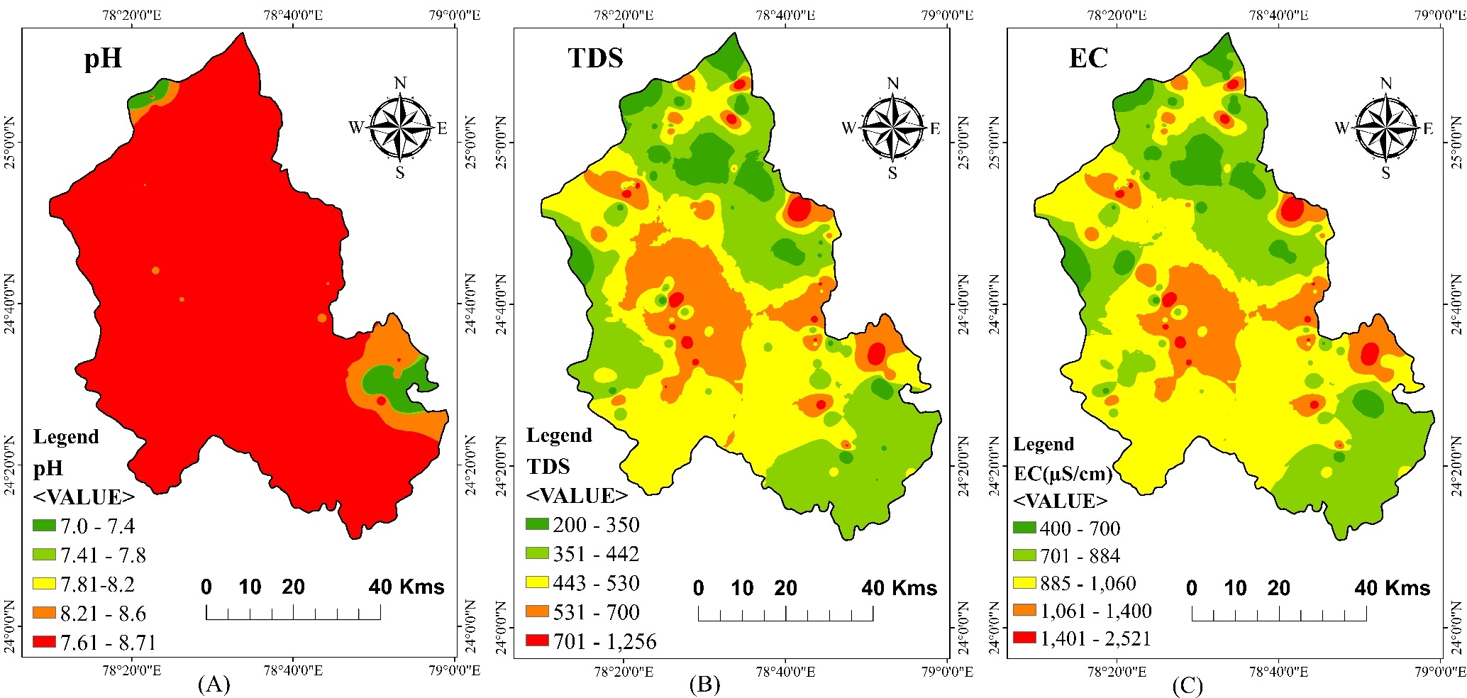
- The integrated approach of the GIS platform and AHP technique reveals spatial variations in GWQI linking poor groundwater quality to low recharge hard rock terrains.
- Effective, precise and informative method for groundwater quality assessment by integrating hydrogeological and physiochemical parameters.
- The close interplay between hydrogeological factors and groundwater quality highlights the crucial role of recharge in mitigating poor groundwater conditions.
- Open Access
- Article
Multicriteria Groundwater Quality Assessment Using AHP–GIS Integration of Physiochemical and Geohydrological Parameters in the Bundelkhand Region, India
- Utkarsh Bisen *,
- Surya Pratap Singh
Author Information
Received: 04 Dec 2025 | Revised: 16 Jan 2026 | Accepted: 14 Feb 2026 | Published: 26 Feb 2026
Highlights
Abstract
This study introduces a novel approach by integrating the Multi-Criteria Decision-Making (MCDM) technique of the Analytical Hierarchy Process (AHP) with Geographic Information System (GIS) to develop a Geospatial Groundwater Quality Index (GWQI) for the semi-arid Lalitpur district. To carry out the GWQI assessment, seven hydrogeological parameters, such as geology, geomorphology, lineament density, drainage density, slope, rainfall and Land use Land cover (LULC) thematic layers, were used in generating GWPZ. These layers were integrated with physiochemical parameters that include pH, TDS, Ca2+ , Mg2+ , Cl− , HCO3− , CO32−, SO42−, F− , and NO3− to generate GWQI. The weights are assigned based on their relative influence on groundwater quality. A Weighted Arithmetically Water Quality Index (WAWQI) map is prepared using physicochemical parameters alone and compared with the GWQI. The WAWQI categorises the study area into Very Poor (1.22%), Poor (11.54%), Moderate (32.41%), Good (43.40%), and Very Good (11.41%) classes. In contrast, the GWQI classified water quality into five categories and the percentage area was found to be Very Good (7 samples, 5.01%), Good (58 samples, 38.39%), Moderate (57 samples, 38.55%), Poor (25 samples, 17.12%), and Unsuitable (3 samples, 0.91%). A sympathetic relationship between the physiochemical parameters and hydrogeological parameters was observed. GWQI integrated method provide more valuable and informative results than WAWQI in the Lalitpur district.
Graphical Abstract
Keywords
multicriteria | bundelkhand | AHP–GIS techniques | groundwater | WQI
References
- 1.
Lakshmi,R.V.; Raja, V.; Sekar, C.P.; et al. Evaluation of Groundwater Quality in Virudhunagar Taluk, Tamil Nadu, India by using statistical methods and GIS Technique. J. Geol. Soc. India 2021, 97, 527–538. https://doi.org/10.1007/s12594-021-1719-x
- 2.
Ram, A.; Tiwari, S.K.; Pandey. H.K.; et al. Groundwater quality assessment using water quality index (WQI) under GIS framework. Appl. Water Sci. 2021, 11, 46. https://doi.org/10.1007/s13201-021-01376-7
- 3.
Brown, R.M.; Mcclelland, N.I.; Deininger, R.A.; et al. A water quality index—crashing the psychological barrier. In Indicators of Environmental Quality: Proceedings of a Symposium Held during the AAAS Meeting in Philadelphia, Pennsylvania, 26–31 December 1971; Springer: Boston, MA, USA, 1972. Available from: https://api.semanticscholar.org/CorpusID:128367096
- 4.
Masood, A.; Aslam, M.; Bao, Q.; et al. Integrating water quality index, GIS and multivariate statistical techniques towards a better understanding of drinking water quality Bureau of Indian Standards. Environ. Sci. Pollut. Res. 2022, 26860–26876. https://doi.org/10.1007/s11356-021-17594-0
- 5.
Pradhan, B. Groundwater potential zonation for basaltic watersheds using satellite remote sensing data and GIS techniques. Cent. Eur. J. Geosci. 2009, 1, 120–129. https://doi.org/10.2478/v10085-009-0008-5
- 6.
Pant, N.; Rai, S.P.; Singh, R.; et al. Impact of geology and anthropogenic activities over the water quality with emphasis on fluoride in water scarce Lalitpur district of Bundelkhand region, India. Chemosphere 2021, 279, 130496.
- 7.
Samadi, J. Modelling hydrogeological parameters to assess groundwater pollution and vulnerability in Kashan aquifer: Novel calibrationvalidation of multivariate statistical methods and human health risk considerations. Environ. Res. 2022, 211, 113028.
- 8.
Tesfaldet, Y.T.; Puttiwongrak, A.; Arpornthip, T. Spatial and temporal variation of groundwater recharge in shallow aquifer in the Thepkasattri of Phuket, Thailand. J. Groundw. Sci. Eng. 2020, 8, 10–19. https://doi.org/10.19637/j.cnki.2305-7068.2020.01.002
- 9.
Ponnusamy, D.; Elumalai, V. Determination of potential recharge zones and its validation against groundwater quality parameters through the application of GIS and remote sensing techniques in uMhlathuze catchment, KwaZulu-Natal, South Africa. Chemosphere. 2022, 307, 136121.
- 10.
Olomo, O.K.; Danga, O.A.; Aliyu, A.O. Exploration of quality groundwater through lineament delineation in Okene and its surroudings. Geosyst. Geoenviron. 2025, 4, 100350.
- 11.
Sengupta, N.; Ghosh, K. Assessment of groundwater suitability using water quality index and health risk analysis in upper catchment area of Kangsabati river, India. Total Environ. Adv. 2024, 11, 200114.
- 12.
Aller, L.; Lehr, J.H.; Petty, R.; et al. DRASTIC: A standardized system to evaluate groundwater pollution potential using hydrogeologic setting. J. Geol. Soc. India 1987, 29, 23–37. https://doi.org/10.17491/jgsi/1987/290112
- 13.
Lasagna, M.; De Luca, D.A.; Debernardi, L.; et al. Effect of the dilution process on the attenuation of contaminants in aquifers. Environ. Earth Sci. 2013, 70, 2767–2784. https://doi.org/10.1007/s12665-013-2336-9
- 14.
Mohapatra, P.; Paul, J.C.; Das, D.M.; et al. Spatial analysis of groundwater quality and potential for irrigation using hydrogeological and water quality parameters: Insights from Bargarh Canal command area. Front. Water 2026, 7, 1674770. https://doi.org/10.3389/frwa.2025.1674770
- 15.
Khemmal, H.Y.; Hani, A.; Benmarce, K. Exploring groundwater recharge potential zones mapping in the northern upper Boussellam region: A novel approach integrating TDS levels. Appl. Water Sci. 2025, 15, 1–21. https://doi.org/10.1007/s13201-025-02413-5
- 16.
Chowdhury, A.; Jha, M.; Chowdary, V.; et al. Integrated remote sensing and GIS-based approach for assessing groundwater potential in West Medinipur district, West Bengal, India. Int. J. Remote Sens. 2009, 30, 231–250. https://doi.org/10.1080/01431160802270131
- 17.
Rajkumar, H.; Naik, P.K.; Rishi, M.S.; A comprehensive water quality index based on analytical hierarchy process. Ecol. Indic. 2022, 145, 109582.
- 18.
Marfo, J.N.; Quaye-Ballard, J.A.; Kwakye, S.O.; et al. Groundwater quality and potential analysis using geospatial techniques: The case of Ashanti Region in Ghana. Heliyon 2024, 10, e27545.
- 19.
Patil, K.P.D.S.S. Spatial distribution of ground water quality index using remote sensing and GIS techniques. Appl. Water Sci. 2022, 12, 1–18. https://doi.org/10.1007/s13201-021-01546-7
- 20.
Lavanya, M.; Muthukumar, M. A comprehensive analysis of groundwater quality: Geospatial and multivariate approaches in Dindigul District, Tamil Nadu, India. Ecohydrol. Hydrobiol. 2025, 25, 598–617.
- 21.
Kumar, M.; Singh, P.; Singh, P. Machine learning and GIS-RS-based algorithms for mapping the groundwater potentiality in the Bundelkhand region, India. Ecol. Inform. 2023, 74, 101980.
- 22.
Ako, T.A.; Onoduku, U.S.; Waziri, S.H.; et al. Assessment of the environmental impacts of marble quarrying on surface water at Kwakuti, Niger state, North Central Nigeria. Int. J. Eng. Adv. Res. Technol. 2015, 1, 64–70.
- 23.
McCarty, M.F. Should we restrict chloride rather than sodium? Med. Hypotheses 2004, 63, 138–148. https://doi.org/10.1016/j.mehy.2003.11.005
- 24.
Shaji, E.; Sarath, K.V.; Santosh, M.; et al. Fluoride contamination in groundwater: A global review of the status, processes, challenges, and remedial measures. Geosci. Front. 2024, 15, 101734.
- 25.
Basu, A.K. Geology of parts of Bundelkhand Granitic Massif. Rec. Geol. Surv. India 1986, 117, 61–124.
- 26.
Singh, S.P.; Singh, M.M.; Srivastava, G.S.; et al. Crustal evolution in Bundelkhand area, Central India. Himal. Geol. 2007, 28, 79–101.
- 27.
Podugu, N.; Ray, L.; Singh, S.P. et al. Heat flow, heat production, and crustal temperatures in the Archaean Bundelkhand craton, north-central India: Implications for thermal regime beneath the Indian shield. J. Geophys. Res. Solid Earth 2017, 122, 5766–5788. https://doi.org/10.1002/2017JB014041
- 28.
District, F. Ground Water Brochure 2009 (May 2007): 2008–09; Central Ground Water Board (CGWB): New Delhi, India, 2009.
- 29.
Singh, S.P.; Subramanyam, K.S.V.; Manikyamba, C.; et al. Geochemical systematics of the Mauranipur-Babina greenstone belt, Bundelkhand Craton, Central India: Insights on Neoarchean mantle plume-arc accretion and crustal evolution. Geosci. Front. 2018, 9, 769–788.
- 30.
Shaji, E.; Santosh, M.; Sarath, K.V.; et al. Groundwater potential and sustainability in the Indian subcontinent. Habitable Planet 2025, 1, 249–270.
- 31.
Renjith, M.L.; Singh, S.P.; Santosh, M.; et al. The Khajraha, oldest carbonatite from India: Implications on carbonated-eclogite source, multi-level emplacement and its petrogenetic link with orthomagmatic fluids. Lithos 2023, 446–447, 107100.
- 32.
Chai, J.; Liu, J.N.K.; Ngai, E.W.T. Application of decision-making techniques in supplier selection: A systematic review of literature. Expert Syst. Appl. 2013, 40, 3872–3885.
- 33.
Saaty, T.L. The analytic hierarchy process: Decision making in complex environments BT–quantitative assessment in arms control: Mathematical modeling and simulation in the analysis of arms control problems. In Quantitative Assessment in Arms Control: Mathematical Modeling and Simulation in the Analysis of Arms Control Problems; Avenhaus, R., Huber, R.K., Eds.; Springer: Boston, MA, USA, 1984; pp. 285–308. Available from: https://doi.org/10.1007/978-14613-2805-6_12
- 34.
Singh, R.; Upreti, P.; Allemailem, K.S.; et al. Geospatial assessment of ground water quality and associated health problems in the Western Region of India. Water 2022, 14, 296. https://doi.org/10.3390/w14030296
- 35.
Zhang, B.; Zhao, D.; Zhou, P.; et al. Hydrochemical characteristics of groundwater and dominantwater-rock interactions in the Delingha area, Qaidam Basin, Northwest China. Water 2020, 12, 836. https://doi.org/10.3390/w12030836
How to Cite
Bisen, U., & Singh, S. P. (2026). Multicriteria Groundwater Quality Assessment Using AHP–GIS Integration of Physiochemical and Geohydrological Parameters in the Bundelkhand Region, India. Habitable Planet, 2(1), 216–233. https://doi.org/10.63335/j.hp.2026.0036
RIS
BibTex
Copyright & License

Copyright (c) 2026 by the authors.
This work is licensed under a Creative Commons Attribution 4.0 International License.
Contents
References
 Suite 4002 Level 4, 447 Collins Street, Melbourne, Victoria 3000, Australia
 General Inquiries: info@sciltp.com