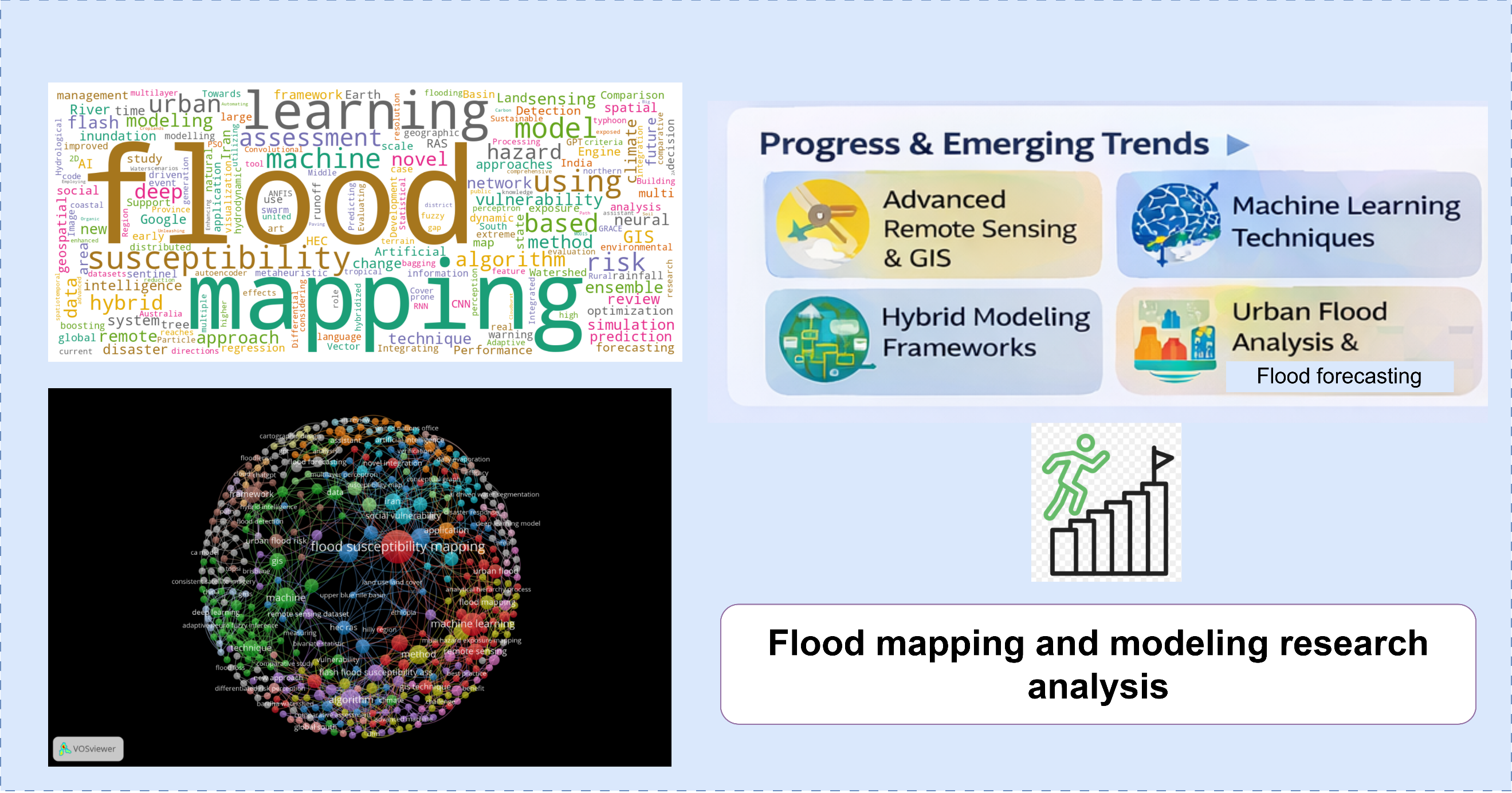
- Reviews 130+ studies on AI-driven flood mapping and modeling advances.
- Highlights hybrid, ensemble, and data-fusion methods for improved flood prediction.
- Identifies key gaps and future directions for next-generation GeoAI in flood analysis.
- Open Access
- Article
Flood Mapping and Modeling: Progress, Challenges and Future Directions
- Vahid Isazadeh 1,2,
- Mahdieh Shirmohammadi 1,3,
- Saied Pirasteh 1,3,4,*,
- Mehdi Akhavan 1
Author Information
Received: 10 Feb 2026 | Revised: 17 Mar 2026 | Accepted: 12 Apr 2026 | Published: 20 Apr 2026
Highlights
Abstract
Floods are among the most widespread and destructive natural hazards, posing persistent threats to human life, infrastructure, and socioeconomic systems worldwide. Over recent decades, flood mapping and modeling have evolved significantly due to advances in remote sensing, Geographic Information Systems (GIS), and data-intensive analytical methods. This review synthesizes recent progress and remaining challenges in flood susceptibility, inundation, hazard, and risk assessment, with particular emphasis on the growing role of machine learning, deep learning, and hybrid modeling frameworks for spatial prediction and decision support. Based on a comprehensive review of more than 130 peerreviewed studies, the paper examines methodological developments spanning conventional hydrological and hydraulic models, data-driven approaches, and integrated hybrid frameworks. These methods increasingly leverage multi-source geospatial data, including satellite imagery, digital elevation models, rainfall products, and socio-environmental indicators. Emerging research trends reveal a shift toward intelligent data fusion, ensemble modelling, hybrid architectures, and Generative Pre-trained Transformer (GPT) architectures that combine physical process understanding with learning-based algorithms to enhance predictive accuracy, robustness, and scalability across diverse climatic and urban settings. The review also highlights thematic advances in urban flood analysis, flash flood susceptibility mapping, real-time forecasting, and model performance evaluation under data uncertainty. Despite substantial progress, key challenges persist related to model generalization, interpretability, data quality, and operational implementation. By critically assessing current methodologies and research gaps, this study outlines future directions for next-generation Geospatial Artificial Intelligence (GeoAI) in flood mapping and modeling.
Graphical Abstract
Keywords
flood mapping | flood modeling | Geospatial Artificial Intelligence (GeoAI) | machine learning | disaster risk assessment
References
- 1.
Bakhtiyarikia, M.; Pirasteh, S.; Pradhan, B.; et al. An artificial neural network model for flood simulation using GIS: Johor River Basin, Malaysia. Environ. Earth Sci. 2011, 67, 251–264. https://doi.org/10.1007/s12665-011-1504-z
- 2.
Habibi, A.; Delavar, M.R.; Nazari, B.; et al. Novel intelligence models for flood hazard: Development of novel hybridized ensemble machine learning models with SA and IG feature selection algorithms. Int. J. Appl. Earth. Obs. Geoinf. 2023, 122, 103443. https://doi.org/10.1016/j.jag.2023.103443
- 3.
Habibi, A.; Delavar, M.R.; Sadeghian, M.S.; et al. A hybrid of ensemble machine learning models with RFE and Boruta Wrapper-based algorithms for flash flood susceptibility assessment. Int. J. Appl. Earth. Obs. Geoinf. 2023, 122, 103401. https://doi.org/10.1016/j.jag.2023.103401
- 4.
Khorrami, B.; Pirasteh, S.; Ali, S.; et al. Statistical downscaling of GRACE TWSA estimates to a 1-km spatial resolution for a localscale surveillance of flooding potential. J. Hydrol. 2023, 129929. https://doi.org/10.1016/j.jhydrol.2023.129929
- 5.
Liu, Z.; Coleman, N.; Patrascu, F.I.; et al. Artificial intelligence for flood risk management: A comprehensive state-of-the-art review and future directions. Int. J. Disaster Risk Reduct. 2024, 117, 105110, https://doi.org/10.1016/j.ijdrr.2024.105110
- 6.
Quang, N.H.; Nguyen, M.N.; Hung, N.M.; et al. AI-based flood mapping from high-resolution ASNARO-2 images: Case study of a severe event in the Center of Vietnam. Nat. Hazards 2025, 121, 17647–17675. https://doi.org/10.1007/s11069-025-07485-9
- 7.
Mudashiru, R.B.; Sabtu, N.; Abustan, I.; et al. Flood hazard mapping methods: A review. J. Hydrol. 2021, 603, 126846.
- 8.
Feng, Y.; Xiao, Q.; Brenner, C.; et al. Determination of building flood risk maps from lidar mobile mapping data. Comput. Environ. Urban Syst. 2022, 93, 101759.
- 9.
Isazade, V.; Qasimi, A.B.; Al Kafy, A.; et al. Simulation of floodprone areas using machine learning and GIS techniques in Samangan Province, Afghanistan. Geod. Cartogr. 2024, 50, 20–29. https://doi.org/10.3846/gac.2024.18555
- 10.
Wang, S.; Zhang, M.; Huang, X.; et al. Urban–rural disparity of social vulnerability to natural hazards in Australia. Sci. Rep. 2022, 12, 13665. https://doi.org/10.1038/s41598-022-17878-6
- 11.
Hussainzad, E.A.; Gou, Z. Climate risk and vulnerability assessment in informal settlements of the global south: A critical review. Land 2024, 13, 1357. https://doi.org/10.3390/land13091357
- 12.
He, W.; Weng, Q. Disparities of urban morphology effects on compound natural risks: A multiscale study across the USA. npj Urban Sustain. 2025, 5, 39. https://doi.org/10.1038/s42949-025-00233-9
- 13.
Babati, Ah.; Isa, Z.; Abdussalam, A.F.; et al. Application of machine learning for coastal flooding. Discov. Cities 2025, 2, 80. https://doi.org/10.1007/s44327-025-00125-8
- 14.
Razavi-Termeh, S.V.; Sadeghi-Niaraki, A.; Jelokhani-Niaraki, M.; et al. Flood susceptibility mapping using optimized deep learning models: A non-structural framework. Appl. Water Sci. 2025, 15, 208. https://doi.org/10.1007/s13201-025-02548-5
- 15.
Berndtsson, R.; Becker, P.; Persson, A.; et al. Drivers of changing urban flood risk: A framework for action. J. Environ. Manag. 2019, 240, 47–56.
- 16.
Bhola, P.K.; Leandro, J.; Disse, M. Building hazard maps with differentiated risk perception for flood impact assessment. Nat. Hazards Earth Syst. Sci. 2020, 20, 2647–2663.
- 17.
Johary, R.; R´ evillion, C.; Catry, T.; et al. Detection of large-scale floods using Google Earth Engine and Google Colab. Remote Sens. 2023, 15, 5368. https://doi.org/10.3390/rs15225368
- 18.
Singh, G.; Rawat, K.S. Mapping flooded areas utilizing Google Earth Engine and open SAR data: A comprehensive approach for disaster response. Discov. Geosci. 2024, 2, 5. https://doi.org/10.1007/s44288-024-00006-4
- 19.
Belay, H.; Melesse, A.M.; Tegegne, G.; et al. Flood inundation mapping using the Google Earth Engine and HEC-RAS under land use/land cover and climate changes in the Gumara Watershed, upper Blue Nile Basin, Ethiopia. Remote Sens. 2025, 17, 1283. https://doi.org/10.3390/rs17071283
- 20.
Adeel, Z.; Alar´con, A.M.; Bakkensen, L., et al. Developing comprehensive methodology for evaluating economic impacts of floods in Canada, Mexico and the United States. Int. J. Disaster Risk Reduc. 2020, 50, 101861. https://doi.org/10.1016/j.ijdrr.2020.101861
- 21.
Zhu, W.; Cao, Z.; Luo, P.; et al. Urban flood-related remote sensing: Research trends, gaps and opportunities. Remote Sens. 2022, 14, 5505. https://doi.org/10.3390/rs14215505
- 22.
Pirasteh, S.; Fang, Y.; Mafi-Gholami, D.; et al. Enhancing vulnerability assessment through spatially explicit modeling of mountain social-ecological systems exposed to multiple environmental hazards. Sci. Total Environ. 2024, 630, 172744. https://doi.org/10.1016/j.scitotenv.2024.172744
- 23.
Roohi, M.; Ghafouri, H.R.; Ashrafi, S.M. Advancing flood disaster management: Leveraging deep learning and remote sensing technologies. Acta Geophys. 2025, 73, 557–575.
- 24.
Pirasteh S.; Mohamed Ghouse Z.S.; Gartner G.; et al. Towards responsible GeoAI frameworks for ethical governance and global sustainability. Earth Syst. Resour. Sustain. 2026, 1, 18–30.
- 25.
Shirmohammadi, M.; Pirasteh, S.; Mafi-Gholami, D.; et al. Sustainable urban and social vulnerability warns Iran’s future. Sustain. Cities Soc. 2025, 131, 106757. https://doi.org/10.1016/j.scs.2025.106757
- 26.
Abutaleb, K.A.; Abdelsalam, A.A.; Khaled, M.A. Unleashing environmental intelligence through AI, image processing, and big data: Paving the path to a sustainable future. In Modelling and Advanced Earth Observation Technologies for Coastal Zone Management; Springer Nature: Cham, Switzerland, 2025; pp. 315–354.
- 27.
Neog, D.R.; Singha, G.; Dev, S.; et al. Artificial intelligence and its application in disaster risk reduction in the agriculture sector. In Disaster Risk Reduction and Rural Resilience: With a Focus on Agriculture, Water, Gender and Technology; Springer Nature: Singapore, 2025; pp. 279–305.
- 28.
Yukun, G.; Jun, Z.; Jigang, Y.; et al. A dynamic visualization based on conceptual graphs to capture the knowledge for disaster education on floods. Nat. Hazards 2023, 119, 203–220. https://doi.org/10.1007/s11069-023-06128-1
- 29.
Dhungana, B.; Liu, W. Urban–rural exposure to flood hazard and social vulnerability in the conterminous United States. ISPRS Int. J. Geo-Info. 2024, 13, 339. https://doi.org/10.3390/ijgi13090339
- 30.
Zhang, Q.; Li, C.; Wen, D.; et al. Global South shows higher urban flood exposures than the Global North under current and future scenarios. Commun. Earth Environ. 2025, 6, 594. https://doi.org/10.1038/s43247-025-02585-7
- 31.
Rogers, J.S.; Maneta, M.P.; Sain, S.R.; et al. The role of climate and population change in global flood exposure and vulnerability. Nat. Commun. 2025, 16, 1287. https://doi.org/10.1038/s41467-025-56654-8
- 32.
Kulkarni, A.; Mohanty, J.; Eldho, T.; et al. A web GIS based integrated flood assessment modeling tool for coastal urban watersheds. Comput. Geosci. 2014, 64, 7–14. https://doi.org/10.1016/j.cageo.2013.11.002
- 33.
Li, Y.; Gong, J.; Liu, H.; et al. Real-time flood simulations using CA model driven by dynamic observation data. Int. J. Geogr. Info. Sci. 2015, 29, 523–535. https://doi.org/10.1080/13658816.2014.968760
- 34.
Hadimlioglu, I.A.; King, S.A.; Starek, M.J. Floodsim: Flood simulation and visualization framework using position-based fluids. ISPRS Int. J. Geo-Info. 2020, 9, 163. https://doi.org/10.3390/ijgi9030163
- 35.
Piadeh, F.; Behzadian, K.; Alani, A.M. A critical review of real-time modelling of flood forecasting in urban drainage systems, J. Hydrol. 2022, 607, 127476. https://doi.org/10.1016/j.jhydrol.2022.127476
- 36.
Aziz, F.; Wang, X.; Mahmood, M.Q.; et al. Coastal urban flood risk management: Challenges and opportunities – A systematic review, J. Hydrol. 2024, 645, 132271. https://doi.org/10.1016/j.jhydrol.2024.132271
- 37.
Pham, B.T.; Avand, M.; Janizadeh, S.; et al. GIS Based hybrid computational approaches for flash flood susceptibility assessment. Water, 2020, 12, 683. https://doi.org/10.3390/w12030683
- 38.
Pham, B.T.; Luu, C.; Van Phong, T.; et al. Can deep learning algorithms outperform benchmark machine learning algorithms in flood susceptibility modeling? J. Hydrol. 2021, 592, 125615. https://doi.org/10.1016/j.jhydrol.2020.125615
- 39.
Javeria, S.; Saud Ahmed, K.; Muhammad, A.; et al. An application of hybrid Bagging-Boosting Decision Trees Ensemble Model for Riverine flood susceptibility mapping and regional risk delineation. Water Resour. Manag. 2025, 39, 547–577. https://doi.org/10.1007/s11269-024-03995-6
- 40.
Darabi, H.; Choubin, B.; Rahmati, O.; et al. Urban flood risk mapping using the GARP and QUEST models: A comparative study of machine learning techniques. J. Hydrol. 2019, 569, 142–154. https://doi.org/10.1016/j.jhydrol.2018.12.002
- 41.
Pourzangbar, A.; Oberle, P.; Kron, A.; et al. Analysis of the utilization of machine learning to map flood susceptibility. J. Flood Risk Manag. 2025, 18, e70042. https://doi.org/10.1111/jfr3.70042
- 42.
Darabi, H.; Haghighi, A.T.; Mohamadi, M.A.; et al. Urban flood risk mapping using data-driven geospatial techniques for a floodprone case area in Iran. Hydrol. Res. 2020, 51, 127–142. https://doi.org/10.2166/nh.2019.090
- 43.
Wahba, M.; Essam, R.; El-Rawy, M.; et al. Forecasting of flash flood susceptibility mapping using random forest regression model and geographic information systems. Heliyon, 2024, 10, e33061. https://doi.org/10.1016/j.heliyon.2024.e33061
- 44.
Wahba, M.; Sharaan, M.; Elsadek, W.M.; et al. Examination of the efficacy of machine learning approaches in the generation of flood susceptibility maps. Environ. Earth Sci. 2024, 83, 429. https://doi.org/10.1007/s12665-024-11588-7
- 45.
Latif, R.M.A.; He, J. Flood susceptibility mapping in Punjab, Pakistan: A hybrid approach integrating remote sensing and analytical hierarchy process. Atmosphere 2024, 16, 22. https://doi.org/10.3390/atmos16010022
- 46.
Lei X.; Chen, W.; Panahi, M.; et al. Urban flood modeling using deep-learning approaches in Seoul, South Korea. J. Hydrol. 2021, 601, 126684. https://doi.org/10.1016/j.jhydrol.2021.126684
- 47.
Shekar, P.R.; Mathew, A.; Yeswanth, P.V.; et al. A combined deep CNN-RNN network for rainfall-runoff modelling in Bardha Watershed, India. Artif. Intell. Geosci. 2024, 5, 100073. https://doi.org/10.1016/j.aiig.2023.100073
- 48.
Alkaabi, K.; Sarfraz, U.; Al Darmaki, S. A deep learning framework for flash-flood-runoff prediction: Integrating CNN-RNN with Neural Ordinary Differential Equations (ODEs). Water, 2025, 17, 1283. https://doi.org/10.3390/w17091283
- 49.
Ahmadlou M.; Al-Fugara, A.K.; Al-Shabeeb, A.R.; et al. Flood susceptibility mapping and assessment using a novel deep learning model combining multilayer perceptron and autoencoder neural networks. J. Flood Risk Manag. 2021, 14, e12683. https://doi.org/10.1111/jfr3.12683
- 50.
Riche, A.; Drias, A.; Guermoui, M.; et al. A novel hybrid deeplearning approach for flood-susceptibility mapping. Remote Sens. 2024, 16, 3673. https://doi.org/10.3390/rs16193673
- 51.
Liu, G.; Wan, Z.; Liu, H.; et al. Factors’ feature optimization and flood susceptibility mapping in hilly regions: An Artificial Intelligence approach. Nat. Hazards 2025, 121, 18601–18620. https://doi.org/10.1007/s11069-024-06639-2
- 52.
Janizadeh, S.; Vafakhah, M.; Kapelan, Z.; et al. Novel Bayesian Additive Regression Tree methodology for flood susceptibility modeling. Water Resour. Manag. 2021, 35, 4621–4646. https://doi.org/10.1007/s11269-021-02972-7
- 53.
Pugliese Viloria, A.D.J.; Folini, A.; Carrion, D.; et al. Hazard susceptibility mapping with machine and deep learning: A literature review. Remote Sens. 2024, 16, 3374. https://doi.org/10.3390/rs16183374
- 54.
Shafizadeh-Moghadam, H.; Valavi, R.; Shahabi, H.; et al. Novel forecasting approaches using combination of machine learning and statistical models for flood susceptibility mapping. J. Environ. Manag. 2018, 217, 1–11. https://doi.org/10.1016/j.jenvman.2018.03.089
- 55.
Dai, Z.; Arabameri, A.; Yariyan, P.; et al. Optimizing flood susceptibility detection using ensemble learning methods. Water Resour. Manag. 2025, 39, 7109–7132. https://doi.org/10.1007/s11269-025-04288-2
- 56.
Saha, A.; Pal, S.C.; Arabameri, A.; et al. Flood susceptibility assessment using novel ensemble of hyperpipes and support vector regression algorithms. Water, 2021, 13, 241. https://doi.org/10.3390/w13020241
- 57.
Khosravi, K.; Pham, B.T.; Chapi, K.; et al. A comparative assessment of decision trees algorithms for flash flood susceptibility modeling at Haraz watershed, northern Iran. Sci. Total Environ. 2018, 627, 744–755. https://doi.org/10.1016/j.scitotenv.2018.01.266
- 58.
Khosravi, K.; Panahi, M.; Golkarian, A.; et al. Convolutional neural network approach for spatial prediction of flood hazard at national scale of Iran. J. Hydrol. 2020, 591, 125552. https://doi.org/10.1016/j.jhydrol.2020.125552
- 59.
Al-Ruzouq, R.; Shanableh, A.; Jena, R.; et al. Flood susceptibility mapping using a novel integration of multi-temporal sentinel-1 data and eXtreme deep learning model. Geosci. Front. 2024, 1, 101780. https://doi.org/10.1016/j.gsf.2023.101780
- 60.
Prasad, P.; Loveson, V.J.; Das, B.; et al. Novel ensemble machine learning models in flood susceptibility mapping. Geocarto Int. 2021, 36, 1–23. https://doi.org/10.1080/10106049.2021.1892209
- 61.
Alzubaidi, L.H.; Pareek, P.K.; Reddy, R.A.; et al. Predicting natural hazards and disaster risks using improved particle swarm optimization based support vector machine. In Proceedings of the 2024 International Conference on Intelligent Algorithms for Computational Intelligence Systems (IACIS), Hassan, India, 23–24 August 2024; pp. 1–5.
- 62.
Pourghasemi, H.R.; Amiri, M.; Edalat, M.; et al. Assessment of urban infrastructures exposed to flood using susceptibility map and Google Earth Engine. IEEE J. Sel. Top. Appl. Earth Obs. Remote Sens. 2021, 14, 1923–1937. https://doi.org/10.1109/JSTARS.2020.3045278
- 63.
Youssef, A.M.; Pourghasemi, H.R.; El-Haddad, B.A. Advanced machine learning algorithms for flood susceptibility modelingperformance comparison: Red Sea, Egypt. Environ. Sci. Pollut. Res. 2022, 29, 66768–66792. https://doi.org/10.1007/s11356-022-19664-3
- 64.
Costache, R.; Pham, Q.B.; Sharifi, E.; et al. Flash-flood susceptibility assessment using multi-criteria decision making and machine learning supported by remote sensing and GIS techniques. Remote Sens. 2019, 12, 106. https://doi.org/10.3390/rs12010106
- 65.
Shahabi, H.; Shirzadi, A.; Ghaderi, K.; et al. Flood detection and susceptibility mapping using sentinel-1 remote sensing data and a machine learning approach: Hybrid intelligence of bagging ensemble based on K-Nearest Neighbor Classifier. Remote Sens. 2020, 12, 266. https://doi.org/10.3390/rs12020266
- 66.
Band, S.S.; Janizadeh, S.; Chandra Pal, S.; et al. Flash flood susceptibility modeling using new approaches of Hybrid and Ensemble Tree-Based machine learning algorithms. Remote Sens. 2020, 12, 3568. https://doi.org/10.3390/rs12213568
- 67.
Kalantar, B.; Ueda, N.; Saeidi, V.; et al. Deep Neural Network utilizing remote sensing datasets for flood hazard susceptibility mapping in Brisbane, Australia. Remote Sens. 2021, 13, 2638. https://doi.org/10.3390/rs13132638
- 68.
Darabi, H.; Rahmati, O.; Naghibi, S.A.; et al. Development of a novel hybrid multi-boosting neural network model for spatial prediction of urban flood. Geocarto Int. 2022, 37, 5716–5741. https://doi.org/10.1080/10106049.2021.1920629
- 69.
Shirmohammadi, M.; Pirasteh, S.; Li, W.; et al. Flood risk mapping and performance efficiency evaluation of machine learning algorithms: Best practice in northern Iran. Int. Arch. Photogramm. Remote Sens. Spatial Inf. Sci. 2025, XLVIII-G-2025, 1347–1352, https://doi.org/10.5194/isprs-archives-XLVIII-G-2025-1347-2025
- 70.
Rahmati, O.; Darabi, H.; Panahi, M.; et al. Development of novel hybridized models for urban flood susceptibility mapping. Sci. Rep. 2020, 10, 12937. https://doi.org/10.1038/s41598-020-69703-7
- 71.
Chamanpira, R.; Babaali, H.; Dehghani, R. Estimation of daily evaporation using a new metaheuristic hybrid SVR method in the moderate Caspian climate of Iran. Pure Appl. Geophys. 2025, 183, 493–514. https://doi.org/10.1007/s00024-025-03812-0
- 72.
Rafiei-Sardooi, E.; Azareh, A.; Choubin, B.; et al. Evaluating urban flood risk using hybrid method of TOPSIS and machine learning. Int. J. Disaster Risk Reduct. 2021, 66, 102614. https://doi.org/10.1016/j.ijdrr.2021.102614
- 73.
Chen, W.; Panahi, M.; Pourghasemi, H.R. Performance evaluation of GIS-based new ensemble data mining techniques of adaptive neuro-fuzzy inference system (ANFIS) with genetic algorithm (GA), differential evolution (DE), and particle swarm optimization (PSO) for landslide spatial modelling. Catena 2017, 157, 310–324. https://doi.org/10.1016/j.catena.2017.05.035
- 74.
Adeel, A.; Jadhav, A.S. Employing Google Earth Engine and machine learning algorithms for soil organic carbon mapping: A comparison study of Sentinel-2A and MODIS images in croplands. J. Indian Soc. Remote Sens. 2026, 54, 341–360. https://doi.org/10.1007/s12524-025-02294-w
- 75.
United Nations Office for Disaster Risk Reduction (UNDRR). UNDRR Annual Report 2020. 2020. Available online: https://www.undrr.org/publication/undrr-annual-report-2020 (accessed on 19 October 2025)
- 76.
United Nations Office for Disaster Risk Reduction (UNDRR) and the International Science Council (ISC) (UNDRR-ISC). UNDRRISC Sendai Hazard Definition and Classification Review. 2020. Available online: https://understandrisk.org/undrr-isc-sendaihazard-definition-and-classification-review/ (accessed on 14 March 2026)
- 77.
Liu, J.; Wang, J.; Xiong, J.; et al. Hybrid models incorporating bivariate statistics and machine learning methods for flash flood susceptibility assessment based on remote sensing datasets. Remote Sens., 2021, 13, 4945. https://doi.org/10.3390/rs13234945
- 78.
Amiri, A.; Soltani, K.; Ebtehaj, I.; et al. A novel machine learning tool for current and future flood susceptibility mapping by integrating remote sensing and geographic information systems. J. Hydrol. 2024, 632, 130936.
- 79.
Tsumita, N.; Piyapong, S.; Kaewkluengklom, R.; et al. Flood susceptibility mapping of urban flood risk: Comparing autoencoder multilayer perceptron and logistic regression models in Ubon Ratchathani, Thailand. Nat. Hazards 2025, 121, 17833–17867. https://doi.org/10.1007/s11069-025-07494-8
- 80.
Ngo, P.-T.T.; Pham, T.D.; Nhu, V.-H.; et al. A novel hybrid quantum-PSO and credal decision tree ensemble for tropical cyclone induced flash flood susceptibility mapping with geospatial data. J. Hydrol. 2021, 596, 125682. https://doi.org/10.1016/j.jhydrol.2020.125682
- 81.
Bui, D.T.; Hoang, N.-D.; Pham, T.-D.; et al. A new intelligence approach based on GIS-based Multivariate Adaptive Regression Splines and metaheuristic optimization for predicting flash flood susceptible areas at high-frequency tropical typhoon area. J. Hydrol. 2019, 575, 314–326. https://doi.org/10.1016/j.jhydrol.2019.05.046
- 82.
Bui, Q.-T.; Nguyen, Q.-H.; Nguyen, X.L.; et al. Verification of novel integrations of swarm intelligence algorithms into deep learning neural network for flood susceptibility mapping. J. Hydrol. 2020, 581, 124379. https://doi.org/10.1016/j.jhydrol.2019.124379
- 83.
Khatooni, K.; Hooshyaripor, F.; MalekMohammadi, B.; et al. A new approach for urban flood risk assessment using coupled SWMM–HEC-RAS-2D model. J. Environ. Manag. 2025, 374, 123849. https://doi.org/10.1016/j.jenvman.2024.123849
- 84.
Nachappa, T.; Ghorbanzadeh, O.; Gholamnia, K.; et al. Multihazard exposure mapping using machine learning for the state of Salzburg, Austria. Remote Sens. 2020, 12, 2757. https://doi.org/10.3390/rs12172757
- 85.
Saravanan, S.; Abijith, D.; Reddy, N.M.; et al. Flood susceptibility mapping using machine learning boosting algorithms techniques in Idukki district of Kerala, India. Urban Clim. 2023, 49, 101503. https://doi.org/10.1016/j.uclim.2023.101503
- 86.
Solaimani, K.; Darvishi, S.; Shokrian, F. Assessment of machine learning algorithms and new hybrid multi-criteria analysis for flood hazard and mapping. Environ. Sci. Pollut. Res. 2024, 31, 32950–32971. https://doi.org/10.1007/s11356-024-33288-9
- 87.
Shirmohammadi, M.; Pirasteh, S.; Li, J.; et al. A novel CNN-LSTM-Attention model to forecast flood susceptibility under global climate scenarios. Gondwana Res. 2025, 154, 82–102. https://doi.org/10.1016/j.gr.2025.12.020
- 88.
Tavus, B.; Can, R.; Kocaman, S. A CNN-based flood mapping approach using sentinel-1 data, ISPRS Ann. Photogram. Remote Sens. Spatial Info. Sci. 2022, V-3-2022, 549–556. https://doi.org/10.5194/isprs-annals-V-3-2022-549-2022
- 89.
Islam, T.; Zeleke, E.B.; Afroz, M.; et al. A systematic review of urban flood susceptibility mapping: Remote sensing, machine learning, and other modeling approaches. Remote Sens. 2025, 17, 524. https://doi.org/10.3390/rs17030524
- 90.
Mou, S.A.; Chowdhury, T.N.; Mannan, A.I.; et al. AI driven water segmentation with deep learning models for enhanced flood monitoring, arXiv 2025, arXiv:2501.08266
- 91.
Mehmood, H. Leveraging large language models for floods mapping and advanced spatial decision support: A user-friendly approach with SATGPT. ITU J. Future Evolving Technol. 2025, 6, 57–66. https://doi.org/10.52953/FEGZ5064
- 92.
Adiyasa, A.; Mantegna, A.N.; Kveladze, I. Automating GISbased cloudburst risk mapping using Generative AI: A framework for scalable hydrological analysis. Hydrology 2025, 12, 196. https://doi.org/10.3390/hydrology12080196
- 93.
Lutjens, B.; Leshchinskiy, B.; Boulais, O.; et al. Generating physically-consistent satellite imagery for climate visualizations. IEEE Trans. Geosci. Remote Sens. 2024, 62, 4213311. https://doi.org/10.1109/TGRS.2024.3493763
- 94.
Bentivoglio, R.; Isufi, E.; Jonkman, S.N.; et al. Deep learning methods for flood mapping: A review of existing applications and future research directions. Hydrol. Earth Syst. Sci. 2022, 26, 4345–4378. https://doi.org/10.5194/hess-26-4345-2022
- 95.
Memduhoglu, A. Towards AI-assisted mapmaking: Assessing the capabilities of GPT-4o in cartographic design. ISPRS Int. J. Geo-Info. 2025, 14, 35. https://doi.org/10.3390/ijgi14010035
- 96.
Hou, S.; Shen, Z.; Liang, J.; et al. Can large language models generate geospatial code? Geo-spat. Inf. Sci. 2025, 28, 1–35. https://doi.org/10.1080/10095020.2025.2535523
- 97.
Hou, S.; Shen, Z.; Zhao, A.; et al. GeoCode-GPT: A large language model for geospatial code generation. Int. J. Appl. Earth Obs. Geoinf. 2025, 129, 104456. https://doi.org/10.1016/j.jag.2025.104456
- 98.
Zhang, Y.; Wei, C.; He, Z.; et al. GeoGPT: An assistant for understanding and processing geospatial tasks. Int. J. Appl. Earth Obs. Geoinf. 2024, 131, 103976, https://doi.org/10.1016/j.jag.2024.103976
- 99.
Zhang, S.; Yang, P.; Xia, J.; et al. Land use/land cover prediction and analysis of the middle reaches of the Yangtze River under different scenarios. Sci. Total Environ. 2022, 833, 155238. https://doi.org/10.1016/j.scitotenv.2022.155238
- 100.
Cools, J.; Innocenti, D.; O’Brien, S. Lessons from flood early warning systems. Environ. Sci. Policy, 2016, 58, 117–122. https://doi.org/10.1016/j.envsci.2016.01.003
- 101.
Chang, M.J.; Chang, H.K.; Chen, Y.C.; et al. A support vector machine forecasting model for typhoon flood inundation mapping and early flood warning systems. Water, 2018, 10, 1734. https://doi.org/10.3390/w10121734
- 102.
Perera, D.; Seidou, O.; Agnihotri, J.; et al. Flood Early Warning Systems: A Review of Benefits, Challenges and Prospects; UNUINWEH: Hamilton, ON, Canada, 2019.
- 103.
Sillmann, J.; Kharin, V.V.; Zwiers, F.W.; et al. Climate extremes indices in the CMIP5 multimodel ensemble: Part 2. Future climate projections. J. Geophys. Res. Atmos. 2013, 118, 2473–2493. https://doi.org/10.1002/jgrd.50188
- 104.
Xiong, J.; Yin, J.; Guo, S.; et al. Integrated flood potential index for flood monitoring in the GRACE era. J. Hydrol. 2021, 603, 127115. https://doi.org/10.1016/j.jhydrol.2021.127115
- 105.
Merwade, V.; Cook, A.; Coonrod, J. GIS techniques for creating river terrain models for hydrodynamic modeling and flood inundation mapping. Environ. Model. Software, 2008, 23, 1300–1311. https://doi.org/10.1016/j.envsoft.2008.03.013
- 106.
Razavi-Termeh, S.V.; Kornejady, A.; Pourghasemi, H.R.; et al. Flood susceptibility mapping using novel ensembles of adaptive neuro-fuzzy inference system and metaheuristic algorithms. Sci. Total Environ. 2018, 615, 438–451. https://doi.org/10.1016/j.scitotenv.2017.09.259
- 107.
Hou, J.; Van Dijk, A.I.; Renzullo, L.J.; et al. Hydromorphological attributes for all Australian river reaches derived from Landsat dynamic inundation remote sensing. Earth Syst. Sci. Data, 2019, 11, 1003–1015. https://doi.org/10.5194/essd-11-1003-2019
- 108.
Talukdar, G.; Swain, J.B.; Patra, K.C. Flood inundation mapping and hazard assessment of Baitarani River basin using hydrologic and hydraulic model. Nat. Hazards 2021, 109, 389–403. https://doi.org/10.1007/s11069-021-04839-5
- 109.
Hocini, N.; Payrastre, O.; Bourgin, F.; et al. Performance of automated methods for flash flood inundation mapping: A comparison of a digital terrain model (DTM) filling and two hydrodynamic methods. Hydrol. Earth Syst. Sci. 2021, 25, 2979–2995. https://doi.org/10.5194/hess-25-2979-2021
- 110.
Costabile, P.; Costanzo, C.; Ferraro, D.; et al. Performances of the new HEC-RAS version 5 for 2-D hydrodynamic-based rainfallrunoff simulations at basin scale: Comparison with a state-of-the art model. Water 2020, 12, 2326. https://doi.org/10.3390/w12092326
- 111.
Zeiger, S.J.; Hubbart, J.A. Measuring and modeling eventbased environmental flows: An assessment of HEC-RAS 2D rainon-grid simulations. J. Environ. Manag. 2021, 285, 112125. https://doi.org/10.1016/j.jenvman.2021.112125
- 112.
Shah, Z.; Saraswat, A.; Samal, D.R.; et al. A single interface for rainfall-runoff simulation and flood assessment—A case of new capability of HEC-RAS for flood assessment and management. Arab. J. Geosci. 2022, 15, 1526. https://doi.org/10.1007/s12517-022-10845-8
- 113.
Kaya, C.M.; Derin, L. Parameters and methods used in flood susceptibility mapping: A review. J. Water Clim. Change, 2023, 14, 1935–1960. https://doi.org/10.2166/wcc.2023.019
- 114.
Li, J.; Liu, J.; Xia, Z.; et al. Accurate simulation of extreme rainfall–flood events via an improved distributed hydrological model. J. Hydrol. 2024, 645, 132190. https://doi.org/10.1016/j.jhydrol.2024.132190
- 115.
Carpenter, J.N.; Lynch, A.W. Survivorship bias and attrition effects in measures of performance persistence, J. Financ. Econ. 1999, 54, 337–374, https://doi.org/10.1016/S0304-405X(99)00040-9
- 116.
Iyer, H.S.; Karasaki, S.; Yi, L.; et al. Harnessing geospatial artificial intelligence (GeoAI) for environmental epidemiology: A narrative review. Curr. Environ. Health Rep. 2025, 12, 34. https://doi.org/10.1007/s40572-025-00497-4
- 117.
Sarker, C.; Mejias, L.; Maire, F.; et al. Flood mapping with convolutional neural networks using spatio-contextual pixel information. Remote Sens. 2019, 11, 2331. https://doi.org/10.3390/rs11192331
- 118.
Priscillia, S.; Schillaci, C.; Lipani, A. Flood susceptibility assessment using artificial neural networks in Indonesia. Artif. Intell. Geosci. 2021, 2, 215–222. https://doi.org/10.1016/j.aiig.2021.07.003
- 119.
Singha, C.; Swain, K.; Meliho, M.; et al. Spatial analysis of flood hazard zoning map using novel hybrid machine learning technique in Assam, India. Remote Sens. 2022, 14, 6229. https://doi.org/10.3390/rs14246229
- 120.
Malik, H.; Feng, J.; Shao, P.; et al. Improving flood forecasting using time-distributed CNN-LSTM model: A time-distributed spatiotemporal method. Earth Sci. Info. 2024, 17, 3455–3474. https://doi.org/10.1007/s12145-024-01378-6
- 121.
Moishin, M.; Deo, R.C.; Prasad, R.; et al. Designing deep-based learning flood forecast model with ConvLSTM hybrid algorithm. IEEE Access, 2021, 9, 50982–50993.
- 122.
Lindersson, S.; Raffetti, E.; Rusca, M.; et al. The wider the gap between rich and poor the higher the flood mortality. Nat. Sustain. 2023, 6, 995–1005. https://doi.org/10.1038/s41893-023-01107-7
- 123.
Zhao, G.; Pang, B.; Xu, Z.; et al. Assessment of urban flood susceptibility using semi-supervised machine learning model. Sci. Total Environ. 2019, 659, 940–949. https://doi.org/10.1016/j.scitotenv.2018.12.217
- 124.
Zhao, B.; Wu, J.; Chen, M.; et al. Seasonally inundated area extraction based on long time-series surface water dynamics for improved flood mapping. ISPRS J. Photogram. Remote Sens. 2024, 217, 32–52, https://doi.org/10.1016/j.isprsjprs.2024.08.002
- 125.
Dodangeh, E.; Choubin, B.; Najafi Eigdir, A.; et al. Integrated machine learning methods with resampling algorithms for flood susceptibility prediction. Sci. Total Environ. 2020, 705, 135983. https://doi.org/10.1016/j.scitotenv.2019.135983
- 126.
Avand, M.; Moradi, H.R.; Ramazanzadeh Lasboyee, M. Spatial prediction of future flood risk: An approach to the effects of climate change. Geosciences 2021, 11: 25. https://doi.org/10.3390/geosciences11010025
- 127.
Khodaei, H.; Nasiri Saleh, F.; Nobakht Dalir, A.; et al. Future flood susceptibility mapping under climate and land use change. Sci. Rep. 2025, 15, 12394. https://doi.org/10.1038/s41598-025-12394-1
- 128.
Arora, A.; Arabameri, A.; Pandey, M.; et al. Optimization of state-of-the-art fuzzy-metaheuristic ANFIS-based machine learning models for flood susceptibility prediction mapping in the Middle Ganga Plain, India. Sci. Total Environ. 2021, 750, 141565. https://doi.org/10.1016/j.scitotenv.2020.141565
- 129.
Parra-S´anchez, D.T. Exploring the Internet of Things adoption in the Fourth Industrial Revolution: A comprehensive scientometric analysis. J. Innov. Digit. Transform. 2025, 2, 1–18. https://doi.org/10.1108/JIDT-06-2024-0013
- 130.
Pirasteh, S.; Mafi-Gholami, D.; Li, H.; et al. Social vulnerability: A driving force in amplifying the overall vulnerability of protected areas to natural hazards. Heliyon, 2025, 11, e42617, https://doi.org/10.1016/j.heliyon.2025.e42617
- 131.
Martelo R.; Wang R.Q. FloodGPT: An Advanced AI Assistant for Flood Risk Management. Available online: https://github.com/RafaelaMartelo/FloodGPT-4 Prototype (accessed on 14 March 2026)
- 132.
Kumbam, P.R.; Vejre, K.M. FloodLense: A framework for ChatGPTbased real-time flood detection, arXiv 2024, arXiv:2401.15501v1
- 133.
Martelo, R.; Ahmadiyehyazdi, K.; Wang, R-Q. Towards democratized flood risk management: An advanced AI assistant enabled by GPT-4 for enhanced interpretability and public engagement, arXiv 2024, arXiv: 2403.03188
How to Cite
Isazadeh, V., Shirmohammadi, M., Pirasteh, S., & Akhavan, M. (2026). Flood Mapping and Modeling: Progress, Challenges and Future Directions. Habitable Planet, 2(2), 285–302. https://doi.org/10.63335/j.hp.2026.0039
RIS
BibTex
Copyright & License

Copyright (c) 2026 by the authors.
This work is licensed under a Creative Commons Attribution 4.0 International License.
Contents
References
 Suite 4002 Level 4, 447 Collins Street, Melbourne, Victoria 3000, Australia
 General Inquiries: info@sciltp.com