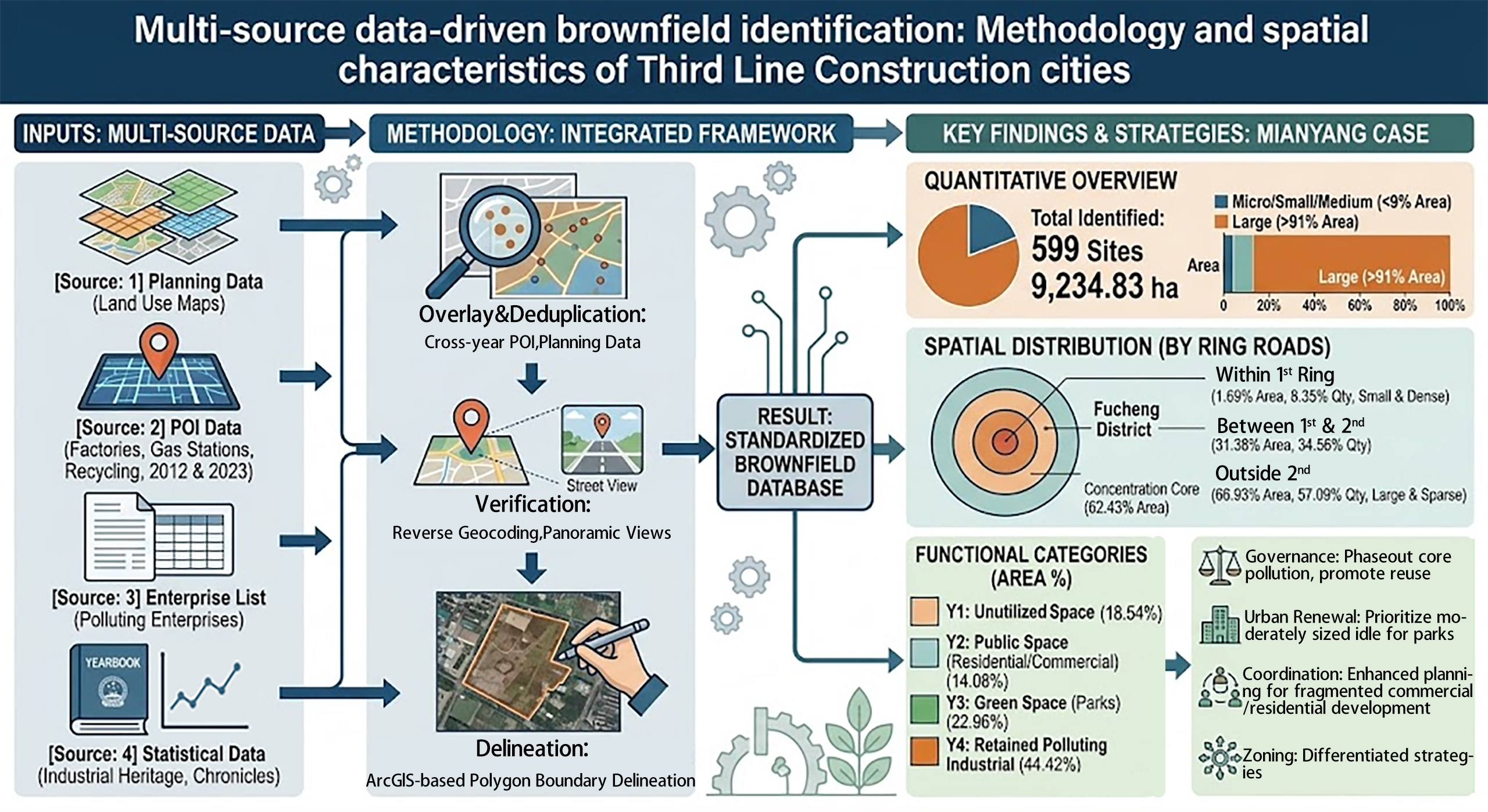
Global practices in brownfield redevelopment have yielded valuable legislative and policy frameworks. However, existing studies lack targeted identification and database construction methodologies for Third Line Construction cities in China, which feature clustered industrial heritage and fragmented land rights, leading to a disconnect between general brownfield research and the actual governance needs of such typical industrial cities. This study addresses these gaps by developing a multi-source data integrated technical framework for systematic brownfield identification and standardized database construction, taking Mianyang—a typical Third Line Construction city—as the case. The framework prioritizes planning data, takes Point of Interest (POI) data as the core supplement, and innovatively integrates satellite imagery and industrial statistics via cross-year POI superimposition-deduplication, coordinate reverse geocoding verification, and ArcGIS-based polygon boundary delineation, effectively compensating for traditional method deficiencies and realizing standardized attribute-spatial data binding. Applying this framework, 599 brownfield sites (9234.83 ha) in Mianyang were identified and classified into four functional categories. Spatial statistical analysis reveals their concentration in Fucheng District and beyond the Second Ring Road, dominance of large-scale plots, and functional differentiation with nearly half remaining polluting industrial land. This study establishes a standardized, replicable process for Third Line Construction cities and a quantitative paradigm for brownfield precise governance.
- Open Access
- Article
Multi-Source Data-Driven Brownfield Identification: Methodology and Spatial Characteristics of Third Line Construction Cities
Author Information
Received: 02 Feb 2026 | Revised: 31 Mar 2026 | Accepted: 31 Mar 2026 | Published: 07 Apr 2026
Abstract
Graphical Abstract
Keywords
multi-source data integration | POI data | spatial analysis | brownfield database construction | industrial heritage cities
References
- 1.
Cao, T. Cao, K.; Jin, T. A discussion on brownfield redevelopment strategies in Western countries and its inspiration to China. China Popul. Environ. 2007, 17, 124–129.
- 2.
Zhang, X. Research on the spatial differentiation and reuse model of brownfields from the multi-scale perspectives. Ph.D. Thesis, Northeast Normal University, Changchun, China, 2021.
- 3.
Liu, B. Construction and application of brownfield database in the Fourth Ring Road of Chengdu based on landscape reuse. Master’s Thesis, Southwest Jiaotong University, Chengdu, China, 2022.
- 4.
Hu, C.; Fan, J.; Chen, J. Spatial and temporal characteristics and drivers of agricultural carbon emissions in Jiangsu Province, China. Int. J. Environ. Res. Public Health 2022, 19, 12463. https://doi.org/10.3390/ijerph191912463.
- 5.
Zheng, D.; Li, C. Research on spatial pattern and its industrial distribution of commercial space in Mianyang based on POI data. J. Data Anal. Inf. Process. 2020, 8, 20–24. https://doi.org/10.4236/jdaip.2020.81002.
- 6.
Li, M. Study on the distribution and utilization of urban residential space based on big data. Master’s Thesis, Southwest University of Science and Technology, Mianyang, China, 2018.
- 7.
Zhao, C.; Zhou, B.; Su, X. Evaluation of urban eco-security—A case study of Mianyang City, China. Sustainability 2014, 6, 2281–2299. https://doi.org/10.3390/su6042281.
- 8.
Lin, H.; Song, Y.; Wang, S. Research on method of urban brownfield information identification and brownfield database construction: Taking Changchun as an example. China L. Sci. 2016, 30, 80–87.
- 9.
Lin, M.; Li, J.; Xie, H. Brownfield identification: Methods and practices. World Reg. Stud. 2013, 22, 169–176.
- 10.
Chen, Y.; Xie, H.; Lin, M. Methodology construction of brownfield identification and its application——A case study of typical site in Fuzhou. J. Hainan Norm. Univ. Nat. Sci. 2013, 26, 452–457.
- 11.
Hao, F.L.; Lu, M.; Yu, T.T.; Wang, S.J. Identification and characterization of urban polycentric structure based on points of interest in Shenyang, China. Growth Chang. 2024, 55, e12697. https://doi.org/10.1111/grow.12697.
- 12.
Zhang, Y.P.; Zhu, A.X.; Sun, Y.; et al. Identification of Urban Functional Zones Considering Point of Interest Differences: A Case Study of Nanjing City. Trans. GIS 2025, 29, e70066. https://doi.org/10.1111/tgis.70066.
- 13.
Egbariya, B.; Dror, R.; Kuflik, T.; Shimshoni, I. Image-based POI identification for mobile museum guides: Design, implementation, and user evaluation. Heritage 2025, 8, 266. https://doi.org/10.3390/heritage8070266.
- 14.
Zhang, J.; Zhuo, L.; Sun, H.; Wang, Y. Construction of the Chinese route of industrial heritage based on spatial and temporal distribution analysis. Buildings 2024, 14, 1065. https://doi.org/10.3390/buildings14041065.
- 15.
Liao, H.; Li, X. Status and trends of research on China’s Third Front Construction in English language and brief comparison with Chinese counterpart. Sage Open 2023, 13, 21582440231157614. https://doi.org/10.1177/21582440231157614.
- 16.
Li, T.; Xiang, M. Study on planning layout and spatial form of the Third-Line Construction in North Sichuan—Taking four cities in Northern Sichuan as examples. Open J. Soc. Sci. 2023, 11, 325–344. https://doi.org/10.4236/jss.2023.111024.
- 17.
Gan, T.; Chen, J.; Yao, M.; et al. Frontier revitalisation of industrial heritage with urban–rural fringe in China. Buildings 2024, 14, 1256. https://doi.org/10.3390/buildings14051256.
- 18.
Deng, J. Study on the equity of spatial distribution of elderly facilities in Mianyang City. Acad. J. Environ. Earth Sci. 2024, 6, 46–52. https://doi.org/10.25236/AJEE.2024.060107.
- 19.
Cao, Q.; Huang, Y.; Ran, B.; et al. Coordination conflicts between urban resilience and urban land evolution in Chinese hilly city of Mianyang. Remote Sens. 2021, 13, 4887. https://doi.org/10.3390/rs13234887.
- 20.
Li, H.; Nielsen, J.Ø.; Chen, R. Rural entrepreneurship development in southwest China: A spatiotemporal analysis. Land 2023, 12, 761. https://doi.org/10.3390/land12040761.
- 21.
Gou, K.; Liu, Y. The one-city monopoly index: Analysis of the potential of seven cities in Sichuan to become provincial sub-centres. In Proceedings of the 7th International Conference on Economy, Management, Law and Education (EMLE 2021), Moscow, Russia, 30–31 December 2021; pp. 238–247.
- 22.
Su, L. Research on the development and changes of cities in the Fujiang River Basin during historical periods. Lect. Notes Hist. 2024, 6, 103–115. https://doi.org/10.23977/history.2024.060115.
- 23.
Chen, M. Mianyang: The legacy of state socialism and local construction. Prov. China 2011, 3, 34–59.
- 24.
Du, H.; Lu, X.; Han, X. Determination of priority control factors for risk management of heavy metal(loid)s in park dust in Mianyang City. Sci. Rep. 2024, 14, 27440. https://doi.org/10.1038/s41598-024-79157-w.
- 25.
Mianyang Municipal People’s Government. Available online: https://www.my.gov.cn/mysrmzf/c100130/zjmy.shtml (accessed on 18 December 2025).
- 26.
Gong, P.; Chen, B.; Li, X.; et al. Mapping essential urban land use categories in China (EULUC-China): Preliminary results for 2018. Sci. Bull. 2020, 65, 182–187. https://doi.org/10.1016/j.scib.2019.12.007.
- 27.
Tang, H. Research on landscape design of Mianyang Yuejin Road industrial heritage block from the perspective of social memory. Master’s Thesis, Chengdu University of Technology, Chengdu, China, 2022.
- 28.
Ren, X. The research of a landscape ecological restoration strategy for Three-line construction industrial sites of Mianyang City. Master’s Thesis, Southwest University of Science and Technology, Mianyang, China, 2018.
- 29.
Ministry of Housing and Urban-Rural Development of the People’s Republic of China. Standard for Planning of Urban Green Space [GB/T51346-2019]. China. Available online: https://www.mohurd.gov.cn/gongkai/zc/wjk/art/2019/art_17339_242194.html (accessed on 12 October 2025).
- 30.
Ministry of Housing and Urban-Rural Development of the People’s Republic of China. Standard for Urban Residential Area Planning and Design [GB50180-2018]. China. Available online: https://www.mohurd.gov.cn/gongkai/zc/wjk/art/2018/art_17339_238590.html (accessed on 30 November 2025).


This work is licensed under a Creative Commons Attribution 4.0 International License.
 Suite 4002 Level 4, 447 Collins Street, Melbourne, Victoria 3000, Australia
 General Inquiries: info@sciltp.com