
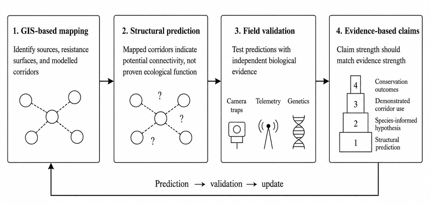
Ecological networks are central tools for addressing habitat fragmentation, but research practice has increasingly shifted from organism-center evidence toward GIS-based mapping and structural connectivity modeling. Remote-sensing data, resistance surfaces, circuit theory and ecosystem-service layers now allow visually persuasive networks to be produced over large areas with limited fieldwork. These approaches are indispensable for broad-scale conservation planning, yet they can blur the distinction between potential connectivity and demonstrated ecological function. A mapped corridor is not necessarily a movement pathway, and structural connectivity does not automatically imply dispersal, gene flow, recolonization or population persistence. This perspective argues that modelled corridors should be treated as testable hypotheses unless they are supported by independent biological evidence. We propose a tiered claim–evidence framework that distinguishes structural predictions, species-informed hypotheses, demonstrated corridor use and demonstrated conservation outcomes. Field validation need not be universal or identical across studies; its intensity should be proportional to claim strength, spatial scale and decision risk. Moving from one-off mapping toward an adaptive prediction–validation–update cycle would make ecological networks more credible scientific and conservation tools.
- Open Access
- Perspective
From GIS-Based Mapping to Ecological Evidence: Why Ecological Networks Still Need Field Validation
- Zechen Wang 1,
- Sicheng Yan 2,
- Yanhui Yan 3,
- Jingeng Huo 4,*,
- Yunlong Pan 5
Author Information
Received: 24 Jul 2026 | Revised: 17 Aug 2026 | Accepted: 31 Aug 2026 | Published: 03 Sep 2026
Abstract
Graphical Abstract
Keywords
ecological network | field validation | structural connectivity | functional connectivity | corridor validation
References
- 1.
Taylor, P.D.; Fahrig, L.; Henein, K.; et al. Connectivity is a vital element of landscape structure. Oikos 1993, 68, 571–573. https://doi.org/10.2307/3544927.
- 2.
Fahrig, L. Effects of habitat fragmentation on biodiversity. Annu. Rev. Ecol. Evol. Syst. 2003, 34, 487–515. https://doi.org/10.1146/annurev.ecolsys.34.011802.132419.
- 3.
Haddad, N.M.; Brudvig, L.A.; Clobert, J.; et al. Habitat fragmentation and its lasting impact on Earth’s ecosystems. Sci. Adv. 2015, 1, e1500052. https://doi.org/10.1126/sciadv.1500052.
- 4.
McRae, B.H.; Dickson, B.G.; Keitt, T.H.; et al. Using circuit theory to model connectivity in ecology, evolution, and conservation. Ecology 2008, 89, 2712–2724. https://doi.org/10.1890/07-1861.1.
- 5.
Zeller, K.A.; McGarigal, K.; Whiteley, A.R. Estimating landscape resistance to movement: A review. Landsc. Ecol. 2012, 27, 777–797. https://doi.org/10.1007/s10980-012-9737-0.
- 6.
Wang, Z.; Huo, J.; Shi, Z.; et al. Ecological security pattern construction integrating “connectivity–importance–niche” approach under vertical zonation: A case study in Funiu Mountain Area, China. Ecol. Evol. 2026, 16, e72848. https://doi.org/10.1002/ece3.72848.
- 7.
Beier, P.; Noss, R.F. Do habitat corridors provide connectivity? Conserv. Biol. 1998, 12, 1241–1252. https://doi.org/10.1111/j.1523-1739.1998.98036.x.
- 8.
Brodie, J.F.; Gonzalez, A.; Mohd-Azlan, J.; et al. A well-connected Earth: The science and conservation of organismal movement. Science 2025, 388, eadn2225. https://doi.org/10.1126/science.adn2225.
- 9.
Laliberté, J.; St-Laurent, M.H. Validation of functional connectivity modeling: The Achilles’ heel of landscape connectivity mapping. Landsc. Urban Plan. 2020, 202, 103878. https://doi.org/10.1016/j.landurbplan.2020.103878.
- 10.
Creech, T.G.; Brennan, A.; Faselt, J.; et al. Validating connectivity models: A synthesis. Curr. Landsc. Ecol. Rep. 2024, 9, 120–134. https://doi.org/10.1007/s40823-024-00102-8.
- 11.
Wang, J.; Tang, H.; Guo, W.; et al. Global hotspots and trends of ecological network research (1991–2024): Insights from bibliometric analysis. Sustainability 2025, 17, 4716. https://doi.org/10.3390/su17104716.
- 12.
Martínez-Richart, A.I.; Zolles, A.; Oettel, J.; et al. A review of structural and functional connectivity studies in European forests. Landsc. Ecol. 2025, 40, 10. https://doi.org/10.1007/s10980-024-02028-2.
- 13.
Pettorelli, N.; Laurance, W.F.; O’Brien, T.G.; et al. Satellite remote sensing for applied ecologists: Opportunities and challenges. J. Appl. Ecol. 2014, 51, 839–848. https://doi.org/10.1111/1365-2664.12261.
- 14.
Tomkiewicz, S.M.; Fuller, M.R.; Kie, J.G.; et al. Global positioning system and associated technologies in animal behaviour and ecological research. Philos. Trans. R. Soc. B Biol. Sci. 2010, 365, 2163–2176. https://doi.org/10.1098/rstb.2010.0090.
- 15.
Kays, R.; Crofoot, M.C.; Jetz, W.; et al. Terrestrial animal tracking as an eye on life and planet. Science 2015, 348, aaa2478. https://doi.org/10.1126/science.aaa2478.
- 16.
Pither, R.; O’Brien, P.; Brennan, A.; et al. Predicting areas important for ecological connectivity throughout Canada. PLoS ONE 2023, 18, e0281980. https://doi.org/10.1371/journal.pone.0281980.
- 17.
Brennan, A.; Bowman, J.; Custode, L.; et al. National-scale multispecies connectivity models represent movements for a majority of species tested. Landsc. Ecol. 2025, 40, 200. https://doi.org/10.1007/s10980-025-02227-5.
- 18.
Beier, P.; Spencer, W.; Baldwin, R.F.; et al. Toward best practices for developing regional connectivity maps. Conserv. Biol. 2011, 25, 879–892. https://doi.org/10.1111/j.1523-1739.2011.01716.x.
- 19.
Poor, E.E.; Scheick, B.K.; Cox, J.J.; et al. Towards robust corridors: A validation framework to improve corridor modeling. Landsc. Ecol. 2024, 39, 177. https://doi.org/10.1007/s10980-024-01971-4.
- 20.
Zeller, K.A.; Jennings, M.K.; Vickers, T.W.; et al. Are all data types and connectivity models created equal? Validating common connectivity approaches with dispersal data. Divers. Distrib. 2018, 24, 868–879. https://doi.org/10.1111/ddi.12742.
- 21.
Liczner, A.R.; Pither, R.; Bennett, J.R.; et al. Advances and challenges in ecological connectivity science. Ecol. Evol. 2024, 14, e70231. https://doi.org/10.1002/ece3.70231.
- 22.
Keeley, A.T.H.; Beier, P.; Belote, R.T.; et al. Comment on: Functional landscape connectivity for a select few: Linkages do not consistently predict wildlife movement or occupancy. Landsc. Urban Plan. 2025, 253, 105217. https://doi.org/10.1016/j.landurbplan.2024.105217.
- 23.
Iverson, A.R.; Waetjen, D.; Shilling, F. Functional landscape connectivity for a select few: Linkages do not consistently predict wildlife movement or occupancy. Landsc. Urban Plan. 2024, 243, 104953. https://doi.org/10.1016/j.landurbplan.2023.104953.
- 24.
Sawaya, M.A.; Kalinowski, S.T.; Clevenger, A.P. Genetic connectivity for two bear species at wildlife crossing structures in Banff National Park. Proc. R. Soc. B 2014, 281, 20131705. https://doi.org/10.1098/rspb.2013.1705.
- 25.
Keeley, A.T.H.; Beier, P.; Creech, T.; et al. Thirty years of connectivity conservation planning: An assessment of factors influencing plan implementation. Environ. Res. Lett. 2019, 14, 103001. https://doi.org/10.1088/1748-9326/ab3234.
- 26.
Hilty, J.; Worboys, G.L.; Keeley, A.; et al. Guidelines for Conserving Connectivity through Ecological Networks and Corridors; Best Practice Protected Area Guidelines Series No. 30; IUCN: Gland, Switzerland, 2020. https://doi.org/10.2305/IUCN.CH.2020.PAG.30.en.


This work is licensed under a Creative Commons Attribution 4.0 International License.

 Suite 4002 Level 4, 447 Collins Street, Melbourne, Victoria 3000, Australia
 General Inquiries: info@sciltp.com