
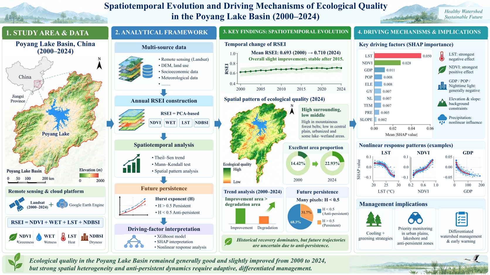
Based on the Google Earth Engine (GEE) platform, this study constructed a Remote Sensing Ecological Index (RSEI) time series for the Poyang Lake Basin from 2000 to 2024. The analysis integrated Theil-Sen median trend estimation, the Mann-Kendall test, the Hurst exponent, and an interpretable machine-learning framework combining extreme gradient boosting (XGBoost) with Shapley additive explanations (SHAP) to examine the spatiotemporal evolution of ecological quality and the factors associated with its spatial heterogeneity. The basin-average RSEI increased slightly from 0.693 in 2000 to 0.710 in 2024, indicating that the basin generally remained at a good ecological level, although interannual fluctuations were evident. Spatially, the RSEI showed a stable pattern of high values in the surrounding mountainous forest belts and lower values in the central plain, urbanized areas, and some lake and wetland zones. The ecological grade structure improved, with the proportion of areas classified as “excellent” increasing from 14.42% to 22.93%. Theil-Sen and Mann-Kendall results showed that areas with historical ecological improvement were more extensive than areas of degradation. However, the Hurst exponent indicated that many pixels exhibited anti-persistent characteristics (H < 0.5), suggesting that future ecological trajectories may be uncertain rather than a simple continuation of historical improvement. XGBoost-SHAP analysis showed that land surface temperature (LST) and NDVI made the largest contributions to RSEI prediction. Because both variables are components of the RSEI, these results should be interpreted as index sensitivity to heat and vegetation conditions rather than independent causal effects. External variables, including GDP, population density, nighttime light intensity, elevation, and slope, showed additional predictive associations with spatial heterogeneity, conditional on the fitted model. These findings not only support differentiated watershed management but also provide a remote sensing perspective on long-term ecological quality changes associated with climate variability and human activities.
- Open Access
- Article
Spatiotemporal Evolution and Associated Factors of Ecological Quality in the Poyang Lake Basin from 2000 to 2024 Based on Remote Sensing
- Daohong Gong 1,2,
- Shuhui Lai 3,4,*,
- Letian Yang 5,
- Xiang Hou 6
Author Information
Received: 03 Mar 2026 | Revised: 13 Sep 2026 | Accepted: 15 Sep 2026 | Published: 09 Oct 2026
Abstract
Graphical Abstract
References
- 1.
Grimm, N.B.; Chapin, F.S.; Bierwagen, B.; et al. The impacts of climate change on ecosystem structure and function. Front. Ecol. Environ. 2013, 11, 474–482. https://doi.org/10.1890/120282.
- 2.
Xiong, Y.; Xu, W.; Lu, N.; et al. Assessment of spatial–temporal changes of ecological environment quality based on RSEI and GEE: A case study in Erhai Lake Basin, Yunnan province, China. Ecol. Indic. 2021, 125, 107518. https://doi.org/10.1016/j.ecolind.2021.107518.
- 3.
Woolway, R.I.; Zhang, Y.; Jennings, E.; et al. Extreme and compound events in lakes. Nat. Rev. Earth Environ. 2025, 6, 593–611. https://doi.org/10.1038/s43017-025-00710-w.
- 4.
Huss, M.; Bookhagen, B.; Huggel, C.; et al. Toward mountains without permanent snow and ice. Earth’s Future 2017, 5, 418–435. https://doi.org/10.1002/2016EF000514.
- 5.
Yuan, B.; Fu, L.; Zou, Y.; et al. Spatiotemporal change detection of ecological quality and the associated affecting factors in Dongting Lake Basin, based on RSEI. J. Clean. Prod. 2021, 302, 126995. https://doi.org/10.1016/j.jclepro.2021.126995.
- 6.
An, M.; Xie, P.; He, W.; et al. Spatiotemporal change of ecologic environment quality and human interaction factors in Three Gorges ecologic economic corridor, based on RSEI. Ecol. Indic. 2022, 141, 109090. https://doi.org/10.1016/j.ecolind.2022.109090.
- 7.
Marceau, D.J.; Hay, G.J. Remote sensing contributions to the scale issue. Can. J. Remote Sens. 1999, 25, 357–366. https://doi.org/10.1080/07038992.1999.10874735.
- 8.
Xu, H.; Wang, Y.; Guan, H.; et al. Detecting ecological changes with a remote sensing based ecological index (RSEI) produced time series and change vector analysis. Remote Sens. 2019, 11, 2345. https://doi.org/10.3390/rs11202345.
- 9.
Schmitz, M.H.; Teixeira-Júnior, J.A.D.; Dantas, D.V.; et al. Assessing land use and climate-related trends in environmental quality using RSEI in a neotropical coastal basin. Environ. Monit. Assess. 2026, 198, 530. https://doi.org/10.1007/s10661-026-15394-y.
- 10.
Novoa, J.; Chokmani, K.; Lhissou, R. A novel index for assessment of riparian strip efficiency in agricultural landscapes using high spatial resolution satellite imagery. Sci. Total Environ. 2018, 644, 1439–1451. https://doi.org/10.1016/j.scitotenv.2018.07.069.
- 11.
Liu, Y.; Dang, C.; Yue, H.; et al. Comparison between modified remote sensing ecological index and RSEI. Natl. Remote Sens. Bull. 2022, 26, 683–697. https://doi.org/10.11834/jrs.20229338.
- 12.
Gong, X.; Li, T.; Wang, R.; et al. Beyond the Remote Sensing Ecological Index: A Comprehensive Ecological Quality Evaluation Using a Deep-Learning-Based Remote Sensing Ecological Index. Remote Sens. 2025, 17, 558. https://doi.org/10.3390/rs17030558.
- 13.
Wang, X.; Wang, X.; Zhang, X.; et al. Spatiotemporal Heterogeneity and Driving Mechanisms of Ecological Quality Based on Modified Remote Sensing Ecological Index and XGBoost–SHAP Analysis. Land Degrad. Dev. 2026, 37, 1143–1159.
- 14.
Xia, J.; Zhang, G.; Ma, S.; et al. Spatial Heterogeneity of Driving Factors in Multi-Vegetation Indices RSEI Based on the XGBoost–SHAP Model: A Case Study of the Jinsha River Basin, Yunnan. Land 2025, 14, 925. https://doi.org/10.3390/land14050925.
- 15.
Zhang, Z.; Chen, X.; Xu, C.Y.; et al. Examining the influence of river–lake interaction on the drought and water resources in the Poyang Lake Basin. J. Hydrol. 2015, 522, 510–521. https://doi.org/10.1016/j.jhydrol.2015.01.008.
- 16.
Zhang, Q.; Liu, J.; Singh, V.P.; et al. Evaluation of impacts of climate change and human activities on streamflow in the Poyang Lake Basin, China. Hydrol. Process. 2016, 30, 2562–2576. https://doi.org/10.1002/hyp.10814.
- 17.
Tian, C.; Zhong, J.; You, Q.; et al. Land use modeling and habitat quality assessment under climate scenarios: A case study of the Poyang Lake Basin. Ecol. Indic. 2025, 172, 113292. https://doi.org/10.1016/j.ecolind.2025.113292.
- 18.
Cheng, L.; Sun, X. Beyond Displacement? Examining the impact of China’s Yellow River floodplain resettlement on farmers’ livelihood resilience: A case study from Jinan, Shandong Province. Habitat Int. 2025, 165, 103538. https://doi.org/10.1016/j.habitatint.2025.103538.
- 19.
Xie, H.; Wen, J.; Chen, Q.; et al. Evaluating the landscape ecological risk based on GIS: A case‐study in the Poyang Lake region of China. Land Degrad. Dev. 2021, 32, 2762–2774. https://doi.org/10.1002/ldr.3951.
- 20.
Tang, X.; Li, H.; Xu, X.; et al. Changing land use and its impact on the habitat suitability for wintering Anseriformes in China's Poyang Lake region. Sci. Total Environ. 2016, 557–558, 296–306. https://doi.org/10.1016/j.scitotenv.2016.03.108.
- 21.
Zeng, X.; Huang, Y.; Xie, H.; et al. Impacts of land use and land cover change on the landscape pattern and ecosystem services in the Poyang Lake Basin, China. Landsc. Ecol. 2024, 39, 183. https://doi.org/10.1007/s10980-024-01976-z.
- 22.
Zhao, Q.; Yu, L.; Li, X.; et al. Progress and trends in the application of Google Earth and Google Earth Engine. Remote Sens. 2021, 13, 3778. https://doi.org/10.3390/rs13183778.
- 23.
Chen, T.; Guestrin, C. XGBoost: A Scalable Tree Boosting System. In Proceedings of the 22nd ACM SIGKDD International Conference on Knowledge Discovery and Data Mining (KDD’16), San Francisco, CA, USA, 13–17 August 2016; pp. 785–794. https://doi.org/10.1145/2939672.2939785.
- 24.
Guo, H.; Hu, Q.; Jiang, T. Annual and seasonal streamflow responses to climate and land-cover changes in the Poyang Lake Basin, China. J. Hydrol. 2008, 355, 106–122. https://doi.org/10.1016/j.jhydrol.2008.03.020.
- 25.
Zhang, Q.; Sun, P.; Jiang, T.; et al. Spatio-temporal patterns of hydrological processes and their responses to human activities in the Poyang Lake Basin, China. Hydrol. Sci. J. 2011, 56, 305–318. https://doi.org/10.1080/02626667.2011.553615.
- 26.
Xu, Z.; Dong, B.; Gao, X.; et al. Land-Use Change and Driving Force Analysis of Wetland in Poyang Lake Based on Remote Sensing. J. Indian Soc. Remote Sens. 2023, 51, 2077–2093. https://doi.org/10.1007/s12524-023-01749-2.
- 27.
Jin, A.; Li, H.; Wang, X.; et al. Spatiotemporal assessment of ecological quality and driving mechanisms in the Beijing metropolitan area. Sci. Rep. 2025, 15, 13136. https://doi.org/10.1038/s41598-025-97156-3.
- 28.
Chen, Y.; He, X.; Tang, Q.; et al. The “Greenness-Quality Paradox” in the Arid Region of Northwest China: Disentangling Non-Linear Drivers via Interpretable Machine Learning. Remote Sens. 2026, 18, 363. https://doi.org/10.3390/rs18020363.
- 29.
Zhong, A.; Hu, Z.; Zhou, J. Assessment of Land Reclamation Effectiveness and Driving Mechanisms in Typical Metal Mining Areas in China Using Remote Sensing and Explainable Machine Learning. Land Degrad. Dev. 2026, 37, 4352–4367. https://doi.org/10.1002/ldr.70377.

This work is licensed under a Creative Commons Attribution 4.0 International License.

 Suite 4002 Level 4, 447 Collins Street, Melbourne, Victoria 3000, Australia
 General Inquiries: info@sciltp.com