Disasters in urban areas are increasingly becoming complicated and this has required resilient positioning, communication and situational-awareness technologies of emergency responders. In this review, the potential of BeiDou Navigation Satellite System (BDS)-based individual rescue equipment in responding to disasters in urban and constructed settings will be discussed. A structured literature review was conducted to study representative rescue devices, including smart helmets, intelligent life jackets and personal positioning terminals, based on their technical functions and uses in disasters. The review combines the current capabilities of BDS-based positioning, satellite short-message communication, sensing integration and emergency information support. The findings indicate that BDS-based rescue systems can be used to enhance responder localisation, emergency communication and operational coordination particularly in situations where the terrestrial communication infrastructure is damaged or unavailable. However, they are constrained by urban signal blockage, multipath and non-line-of-sight effects, indoor positioning, power consumption and system integration problems. It is possible to note that the primary benefit of BDS, when compared to other GNSS constellations, is not necessarily a more accurate positioning in all circumstances, but a set of competitive PNT services and satellite short-message communication service. It also needs to be enhanced regarding hybrid positioning, multi-sensor fusion, low-power device design and integration with smart-city and digital-twin emergency-management platforms. These advances are essential to transform BDS-enabled rescue devices from standalone tools into components of resilient urban emergency-response networks.
- Open Access
- Review
BeiDou-Enabled Personal Rescue Equipment for Urban Disaster Response: Functions, Scenarios and Technical Constraints
- Xun Liu 1,2,*,†,
- Xinqiao Wei 3,†,
- Xiaohui Tang 1,
- Farid Wajdi Akashah 4,*
Author Information
Received: 19 Jun 2026 | Revised: 07 Oct 2026 | Accepted: 08 Oct 2026 | Published: 22 Oct 2026
Abstract
Graphical Abstract
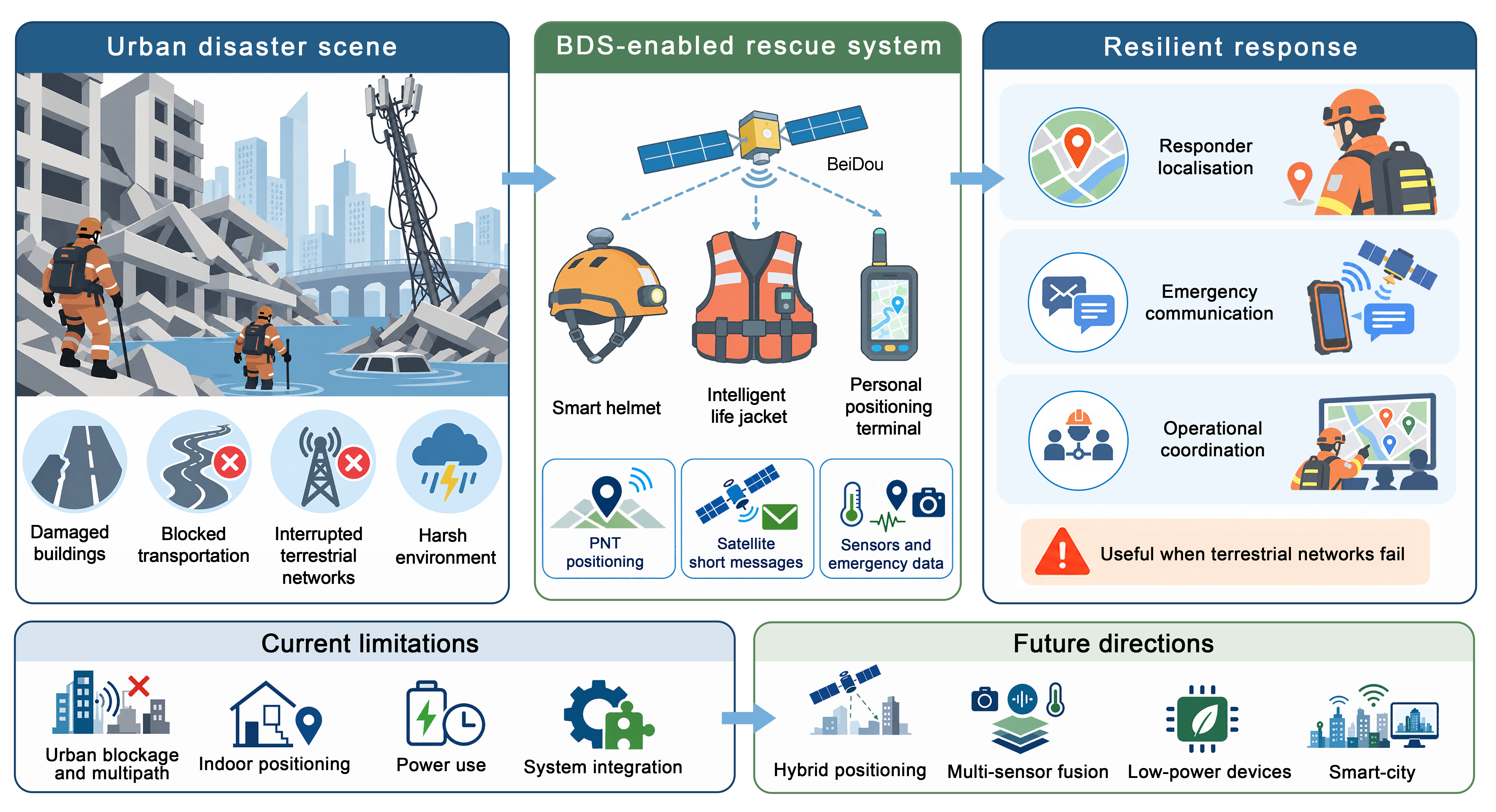
Keywords
BeiDou Navigation Satellite System (BDS) | emergency rescue | personal rescue equipment | urban disaster response | Positioning, Navigation and Timing (PNT) | short-message communication
References
- 1.
Wang, Q.; Li, W.; Yu, Z.; et al. An Overview of Emergency Communication Networks. Remote Sens. 2023, 15, 1595. https://doi.org/10.3390/rs15061595.
- 2.
Song, H.; Chung, J.M. Next-Generation Wireless Communication Technologies for Improved Disaster Response and Management. ETRI J. 2025, 47, 375–392. https://doi.org/10.4218/etrij.2024-0546.
- 3.
Alghisi, M.; Biagi, L. Positioning with GNSS and 5G: Analysis of Geometric Accuracy in Urban Scenarios. Sensors 2023, 23, 2181. https://doi.org/10.3390/s23042181.
- 4.
Zhu, N.; Marais, J.; Betaille, D.; et al. GNSS Position Integrity in Urban Environments: A Review of Literature. IEEE Trans. Intell. Transp. Syst. 2018, 19, 2762–2778. https://doi.org/10.1109/tits.2017.2766768.
- 5.
Boyle, A.; Tolentino, M.E. Localization within Hostile Indoor Environments for Emergency Responders. Sensors 2022, 22, 5134. https://doi.org/10.3390/s22145134.
- 6.
Hailu, T.G.; Guo, X.; Si, H. Indoor Positioning Systems as Critical Infrastructure: An Assessment for Enhanced Location-Based Services. Sensors 2025, 25, 4914. https://doi.org/10.3390/s25164914.
- 7.
Saputra, H.; Alayham Abbas Helmi, R.; Ghazali, M.D.; et al. Urban resilience through IoT-Based disaster preparedness and infrastructure monitoring: A systematic literature review. Nat. Hazards Res. 2025. https://doi.org/10.1016/j.nhres.2025.09.005.
- 8.
Yang, Y.; Gao, W.; Guo, S.; et al. Introduction to BeiDou-3 navigation satellite system. Navigation 2019, 66, 7–18. https://doi.org/10.1002/navi.291.
- 9.
Gao, W.; Zhou, W.; Tang, C.; et al. High-precision services of BeiDou navigation satellite system (BDS): Current state, achievements, and future directions. Satell. Navig. 2024, 5, 20. https://doi.org/10.1186/s43020-024-00143-8.
- 10.
Li, G.; Guo, S.; Lv, J.; et al. Introduction to global short message communication service of BeiDou-3 navigation satellite system. Adv. Space Res. 2021, 67, 1701–1708. https://doi.org/10.1016/j.asr.2020.12.011.
- 11.
Lee, P.; Kim, H.; Zitouni, M.S.; et al. Trends in Smart Helmets With Multimodal Sensing for Health and Safety: Scoping Review. JMIR mHealth uHealth 2022, 10, e40797. https://doi.org/10.2196/40797.
- 12.
Hegarty-Craver, M.; Davis-Wilson, H.; Gaur, P.; et al. Wearable Sensors for Service Members and First Responders: Considerations for Using Commercially Available Sensors in Continuous Monitoring; RTI Press: Research Triangle Park, NC, USA, 2024. https://doi.org/10.3768/rtipress.2024.op.0090.2402.
- 13.
Fernández-García, A.; Oregui Biain, X.; Lingos, K.; et al. Smart Helmet: Combining Sensors, AI, Augmented Reality, and Personal Protection to Enhance First Responders’ Situational Awareness. IT Prof. 2023, 25, 45–53. https://doi.org/10.1109/mitp.2023.3335901.
- 14.
Rasouli, S.; Alipouri, Y.; Chamanzad, S. Smart Personal Protective Equipment (PPE) for construction safety: A literature review. Saf. Sci. 2024, 170, 106368. https://doi.org/10.1016/j.ssci.2023.106368.
- 15.
Mallik, M.; Panja, A.K.; Chowdhury, C. Paving the way with machine learning for seamless indoor–outdoor positioning: A survey. Inf. Fusion 2023, 94, 126–151. https://doi.org/10.1016/j.inffus.2023.01.023.
- 16.
Daud, A.; Al Abdouli, K.M.; Badshah, A. Emerging Computing Tools for Emergency Management: Applications, Limitations and Future Prospects. IEEE Open J. Comput. Soc. 2025, 6, 627–644. https://doi.org/10.1109/ojcs.2025.3563759.
- 17.
Xu, C.; Sun, S.; Zhou, Y.; et al. Research on a Vehicle-Mounted Emergency Communication System Using BeiDou Regional Short Message Communication (RSMC) for Firefighting Operations in Forest Areas without a Public Network. Forests 2024, 15, 1185. https://doi.org/10.3390/f15071185.
- 18.
He, K.; Weng, D.; Ji, S.; et al. Ocean Real-Time Precise Point Positioning with the BeiDou Short-Message Service. Remote Sens. 2020, 12, 4167. https://doi.org/10.3390/rs12244167.
- 19.
Page, M.J.; McKenzie, J.E.; Bossuyt, P.M.; et al. The PRISMA 2020 Statement: An Updated Guideline for Reporting Systematic Reviews. BMJ 2021, 372, n71. https://doi.org/10.1136/bmj.n71.
- 20.
Snyder, H. Literature review as a research methodology: An overview and guidelines. J. Bus. Res. 2019, 104, 333–339. https://doi.org/10.1016/j.jbusres.2019.07.039.
- 21.
Grant, M.J.; Booth, A. A typology of reviews: An analysis of 14 review types and associated methodologies. Health Inf. Libr. J. 2009, 26, 91–108. https://doi.org/10.1111/j.1471-1842.2009.00848.x.
- 22.
Lu, J.; Guo, X.; Su, C. Global capabilities of BeiDou Navigation Satellite System. Satell. Navig. 2020, 1, 27. https://doi.org/10.1186/s43020-020-00025-9.
- 23.
Xu, Y.; Yang, Y.; Li, J. Performance evaluation of BDS-3 PPP-B2b precise point positioning service. GPS Solut. 2021, 25, 142. https://doi.org/10.1007/s10291-021-01175-2.
- 24.
Tao, J.; Liu, J.; Hu, Z.; et al. Initial Assessment of the BDS-3 PPP-B2b RTS Compared with the CNES RTS. GPS Solut. 2021, 25, 131. https://doi.org/10.1007/s10291-021-01168-1.
- 25.
Zhang, R.; He, Z.; Ma, L.; et al. Analysis of BDS-3 PPP-B2b Positioning and Time Transfer Service. Remote Sens. 2022, 14, 2769. https://doi.org/10.3390/rs14122769.
- 26.
Liu, W.; Jiao, B.; Hao, J.; et al. Signal-in-space range error and positioning accuracy of BDS-3. Sci. Rep. 2022, 12, 8181. https://doi.org/10.1038/s41598-022-12012-y.
- 27.
Yang, Y.; Liu, L.; Li, J.; et al. Featured services and performance of BDS-3. Sci. Bull. 2021, 66, 2135–2143. https://doi.org/10.1016/j.scib.2021.06.013.
- 28.
Zhou, F.; Wang, X. Some Key Issues on Pseudorange-Based Point Positioning with GPS, BDS-3, and Galileo Observations. Remote Sens. 2023, 15, 797. https://doi.org/10.3390/rs15030797.
- 29.
Yuan, Y.; Mi, X.; Zhang, B. Initial assessment of single- and dual-frequency BDS-3 RTK positioning. Satell. Navig. 2020, 1, 31. https://doi.org/10.1186/s43020-020-00031-x.
- 30.
Zhang, W.; Lou, Y.; Song, W.; et al. Initial assessment of BDS-3 precise point positioning service on GEO B2b signal. Adv. Space Res. 2022, 69, 690–700. https://doi.org/10.1016/j.asr.2021.09.006.
- 31.
Geng, T.; Cheng, L.; Xie, X.; et al. GNSS real-time precise point positioning with BDS-3 global short message communication devices. Adv. Space Res. 2022, 70, 576–586. https://doi.org/10.1016/j.asr.2022.04.068.
- 32.
Wen, W.; Hsu, L.T. 3D LiDAR Aided GNSS NLOS Mitigation in Urban Canyons. IEEE Trans. Intell. Transp. Syst. 2022, 23, 18224–18236. https://doi.org/10.1109/tits.2022.3167710.
- 33.
Wang, J.; Xu, B.; Liu, J.; et al. Sky-GVIO: Enhanced GNSS/INS/Vision Navigation with FCN-Based Sky Segmentation in Urban Canyon. Remote Sens. 2024, 16, 3785. https://doi.org/10.3390/rs16203785.
- 34.
Xu, X.; Nie, Z.; Wang, Z.; et al. Performance Assessment of BDS-3 PPP-B2b/INS Loosely Coupled Integration. Remote Sens. 2022, 14, 2957. https://doi.org/10.3390/rs14132957.
- 35.
Kodheli, O.; Lagunas, E.; Maturo, N.; et al. Satellite Communications in the New Space Era: A Survey and Future Challenges. IEEE Commun. Surv. Tutorials 2021, 23, 70–109. https://doi.org/10.1109/comst.2020.3028247.
- 36.
Damaševičius, R.; Bacanin, N.; Misra, S. From Sensors to Safety: Internet of Emergency Services (IoES) for Emergency Response and Disaster Management. J. Sens. Actuator Netw. 2023, 12, 41. https://doi.org/10.3390/jsan12030041.
- 37.
Sun, W.; Bocchini, P.; Davison, B.D. Applications of artificial intelligence for disaster management. Nat. Hazards 2020, 103, 2631–2689. https://doi.org/10.1007/s11069-020-04124-3.
- 38.
Abid, S.K.; Sulaiman, N.; Chan, S.W.; et al. Toward an Integrated Disaster Management Approach: How Artificial Intelligence Can Boost Disaster Management. Sustainability 2021, 13, 12560. https://doi.org/10.3390/su132212560.
- 39.
Shaposhnyk, O.; Lai, K.; Wolbring, G.; et al. Next Generation Computing and Communication Hub for First Responders in Smart Cities. Sensors 2024, 24, 2366. https://doi.org/10.3390/s24072366.
- 40.
Álvarez-Merino, C.S.; Khatib, E.J.; Luo-Chen, H.Q.; et al. Victim Detection and Localization in Emergencies. Sensors 2022, 22, 8433. https://doi.org/10.3390/s22218433.
- 41.
Adame, T.; Igual, J.; Catalan, M. Fast Deployment of a UWB-Based IPS for Emergency Response Operations. Sensors 2023, 23, 4193. https://doi.org/10.3390/s23094193.
- 42.
Dahlke, D.; Drakoulis, P.; Fernández García, A.; et al. Seamless Fusion: Multi-Modal Localization for First Responders in Challenging Environments. Sensors 2024, 24, 2864. https://doi.org/10.3390/s24092864.
- 43.
Shi, D.; Gidion, G.; Aftab, T.; et al. Frequency Comb-Based Ground-Penetrating Bioradar: System Implementation and Signal Processing. Sensors 2023, 23, 1335. https://doi.org/10.3390/s23031335.
- 44.
Hwang, S.H.; Maeng, J.H. Simulation Study of Multi-GNSS Positioning Systems in Urban Canyon Environments. Electronics 2025, 14, 3485. https://doi.org/10.3390/electronics14173485.
- 45.
Lyu, M.; Zhao, Y.; Huang, C.; et al. Unmanned Aerial Vehicles for Search and Rescue: A Survey. Remote Sens. 2023, 15, 3266. https://doi.org/10.3390/rs15133266.
- 46.
Zhou, T.; Yang, J.; Long, Q.; et al. Design of an Intelligent Water-Rescue Life Jacket System Based on Satellite Positioning. In Proceedings of the 2023 13th International Conference on Information Technology in Medicine and Education (ITME), Wuyishan, China, 24–26 November 2023; pp. 510–514. https://doi.org/10.1109/itme60234.2023.00107.
- 47.
Destefanis, T.; Guliyeva, S.; Boccardo, P.; et al. Advancing Flood Detection and Mapping: A Review of Earth Observation Services, 3D Data Integration, and AI-Based Techniques. Remote Sens. 2025, 17, 2943. https://doi.org/10.3390/rs17172943.
- 48.
Hlal, M.; Baraka Munyaka, J.C.; Chenal, J.; et al. Digital Twin Technology for Urban Flood Risk Management: A Systematic Review of Remote Sensing Applications and Early Warning Systems. Remote Sens. 2025, 17, 3104. https://doi.org/10.3390/rs17173104.
- 49.
Apriliansyah, B.A.; Iqbal, M. LoRa based long-range traceable life jacket system design. BIO Web Conf. 2024, 106, 01003. https://doi.org/10.1051/bioconf/202410601003.
- 50.
Sarkar, S. Smart Life Safety Jacket for Rescuers. Int. J. Disaster Risk Manag. 2025, 7, 367–384. https://doi.org/10.18485/ijdrm.2025.7.1.21.
- 51.
Chen, Z.; Huang, G.; Xie, W.; et al. GNSS Real-Time Warning Technology for Expansive Soil Landslide—A Case in Ningming Demonstration Area. Remote Sens. 2023, 15, 2772. https://doi.org/10.3390/rs15112772.
- 52.
Gamperl, M.; Singer, J.; Thuro, K. Internet of Things Geosensor Network for Cost-Effective Landslide Early Warning Systems. Sensors 2021, 21, 2609. https://doi.org/10.3390/s21082609.
- 53.
Liao, Y.; Wu, L.; Liu, P.; et al. A Novel High-Frequency Landslide Monitoring Device Based on MEMS Sensors and Real-Time Early Warning Method. Appl. Sci. 2026, 16, 282. https://doi.org/10.3390/app16010282.
- 54.
Xi, R.; Jiang, W.; Meng, X.; et al. Bridge monitoring using BDS-RTK and GPS-RTK techniques. Measurement 2018, 120, 128–139. https://doi.org/10.1016/j.measurement.2018.02.001.
- 55.
Han, J.; Tu, R.; Lu, X.; et al. Analysis of BDS/GPS Deformation Monitoring for the Lake Sarez Dam. Remote Sens. 2023, 15, 4773. https://doi.org/10.3390/rs15194773.
- 56.
Chen, J.; Yue, D.; Liu, Z.; et al. Experimental research on daily deformation monitoring of bridge using BDS/GPS. Surv. Rev. 2019, 51, 472–482. https://doi.org/10.1080/00396265.2018.1481699.
- 57.
Zhang, H.; Yang, J.; Lan, S.; et al. On-site monitoring of expansive soil slope protected by soilbags based on the universal Beidou monitoring system. Phys. Chem. Earth Parts A/B/C 2024, 136, 103775. https://doi.org/10.1016/j.pce.2024.103775.
- 58.
Yang, S.; Huang, Q.; Yu, M. Advancements in remote sensing for active fire detection: A review of datasets and methods. Sci. Total Environ. 2024, 943, 173273. https://doi.org/10.1016/j.scitotenv.2024.173273.
- 59.
Guiop-Servan, R.E.; Cotrina-Sanchez, A.; Puerta-Culqui, J.; et al. Remote Sensing for Wildfire Mapping: A Comprehensive Review of Advances, Platforms, and Algorithms. Fire 2025, 8, 316. https://doi.org/10.3390/fire8080316.
- 60.
Merchán-Cruz, E.A.; Moveh, S.; Pasha, O.; et al. Smart Safety Helmets with Integrated Vision Systems for Industrial Infrastructure Inspection: A Comprehensive Review of VSLAM-Enabled Technologies. Sensors 2025, 25, 4834. https://doi.org/10.3390/s25154834.
- 61.
Zhang, J.; Feng, H.; Ngeh, C.J.; et al. Designing a Smart Helmet for Wildland Firefighters to Avoid Dehydration by Monitoring Bio-Signals. In Proceedings of the CHI ’21: CHI Conference on Human Factors in Computing Systems, Yokohama, Japan, 8–13 May 2021; pp. 1–7. https://doi.org/10.1145/3411763.3451772.
- 62.
Choi, M.; Li, G.; Todrzak, R.; et al. Designing a LoRa-based Smart Helmet to Aid in Emergency Detection by Monitoring Bio-signals. In Proceedings of the 2021 IEEE Global Humanitarian Technology Conference (GHTC), Seattle, WA, USA, 19–23 October 2021; pp. 72–75. https://doi.org/10.1109/ghtc53159.2021.9612483.
- 63.
Ni, C.; Jiang, S.; Li, S.; et al. A Multi-Node Wearable Monitoring System for Firefighters With Edge AI and LoRa-BLE Heterogeneous Communication. Saf. Sci. Technol. 2026, 1, e70015. https://doi.org/10.1002/sst3.70015.
- 64.
Taborri, J.; Pasinetti, S.; Cardinali, L.; et al. Preventing and Monitoring Work-Related Diseases in Firefighters: A Literature Review on Sensor-Based Systems and Future Perspectives in Robotic Devices. Int. J. Environ. Res. Public Health 2021, 18, 9723. https://doi.org/10.3390/ijerph18189723.
- 65.
Xu, P.; Zhang, G.; Zhong, Y.; et al. A Framework for Graphical GNSS Multipath and NLOS Mitigation. IEEE Trans. Intell. Transp. Syst. 2024, 25, 12176–12186. https://doi.org/10.1109/tits.2024.3374819.
- 66.
Groves, P.D. Shadow Matching: A New GNSS Positioning Technique for Urban Canyons. J. Navig. 2011, 64, 417–430. https://doi.org/10.1017/s0373463311000087.
- 67.
Yang, Y.; Mao, Y.; Sun, B. Basic performance and future developments of BeiDou global navigation satellite system. Satell. Navig. 2020, 1, 1. https://doi.org/10.1186/s43020-019-0006-0.
- 68.
Kim, H.I.; Park, K.D. Satellite Positioning Accuracy Improvement in Urban Canyons Through a New Weight Model Utilizing GPS Signal Strength Variability. Sensors 2025, 25, 4678. https://doi.org/10.3390/s25154678.
- 69.
Ma, C.; Pan, S.; Gao, W.; et al. Improving GNSS/INS Tightly Coupled Positioning by Using BDS-3 Four-Frequency Observations in Urban Environments. Remote Sens. 2022, 14, 615. https://doi.org/10.3390/rs14030615.
- 70.
Xiao, P.; Sun, F.; Wang, K.; et al. Positioning performance analysis of real-time BDS-3 PPP-B2b/INS tightly coupled integration in urban environments. Adv. Space Res. 2023, 72, 4008–4020. https://doi.org/10.1016/j.asr.2023.07.013.
- 71.
Chen, J.; Zhao, X.; Liu, C.; et al. Evaluating the Latest Performance of Precise Point Positioning in Multi-GNSS/RNSS: GPS, GLONASS, BDS, Galileo and QZSS. J. Navig. 2021, 74, 247–267. https://doi.org/10.1017/s0373463320000508.
- 72.
Jin, S.; Wang, Q.; Dardanelli, G. A Review on Multi-GNSS for Earth Observation and Emerging Applications. Remote Sens. 2022, 14, 3930. https://doi.org/10.3390/rs14163930.
- 73.
Zhang, P.; Tu, R.; Wu, W.; et al. Initial accuracy and reliability of current BDS-3 precise positioning, velocity estimation, and time transfer (PVT). Adv. Space Res. 2020, 65, 1225–1234. https://doi.org/10.1016/j.asr.2019.11.006.
- 74.
Montenbruck, O.; Steigenberger, P. The 2024 GPS accuracy improvement initiative. GPS Solut. 2025, 29, 33. https://doi.org/10.1007/s10291-024-01793-6.
- 75.
Martini, I.; Susi, M.; Cucchi, L.; et al. Galileo high accuracy service performance and anomaly mitigation capabilities. GPS Solut. 2024, 28, 25. https://doi.org/10.1007/s10291-023-01555-w.
- 76.
Naciri, N.; Yi, D.; Bisnath, S.; et al. Assessment of Galileo High Accuracy Service (HAS) test signals and preliminary positioning performance. GPS Solut. 2023, 27, 73. https://doi.org/10.1007/s10291-023-01410-y.
- 77.
Kiliszek, D.; Kroszczyński, K. Performance of the precise point positioning method along with the development of GPS, GLONASS and Galileo systems. Measurement 2020, 164, 108009. https://doi.org/10.1016/j.measurement.2020.108009.
- 78.
Hamza, V.; Stopar, B.; Sterle, O.; et al. Observations and Positioning Quality of Low-Cost GNSS Receivers: A Review. GPS Solut. 2024, 28, 149. https://doi.org/10.1007/s10291-024-01686-8.
- 79.
Yang, Y.; Ding, Q.; Gao, W.; et al. Principle and performance of BDSBAS and PPP-B2b of BDS-3. Satell. Navig. 2022, 3, 5. https://doi.org/10.1186/s43020-022-00066-2.
- 80.
Cheng, R.; Hou, L.; Xu, S. A Review of Digital Twin Applications in Civil and Infrastructure Emergency Management. Buildings 2023, 13, 1143. https://doi.org/10.3390/buildings13051143.
- 81.
Lagap, U.; Ghaffarian, S. Digital post-disaster risk management twinning: A review and improved conceptual framework. Int. J. Disaster Risk Reduct. 2024, 110, 104629. https://doi.org/10.1016/j.ijdrr.2024.104629.
- 82.
Macatulad, E.; Biljecki, F. Continuing from the Sendai Framework midterm: Opportunities for urban digital twins in disaster risk management. Int. J. Disaster Risk Reduct. 2024, 102, 104310. https://doi.org/10.1016/j.ijdrr.2024.104310.
- 83.
Wang, Y.; Yue, Q.; Lu, X.; et al. Digital twin approach for enhancing urban resilience: A cycle between virtual space and the real world. Resilient Cities Struct. 2024, 3, 34–45. https://doi.org/10.1016/j.rcns.2024.06.002.
- 84.
Khan, A.; Gupta, S.; Gupta, S.K. Emerging UAV technology for disaster detection, mitigation, response, and preparedness. J. Field Robot. 2022, 39, 905–955. https://doi.org/10.1002/rob.22075.


This work is licensed under a Creative Commons Attribution 4.0 International License.